Half-Told Story |
||||||||||||
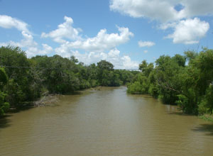
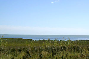
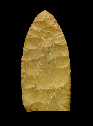
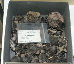
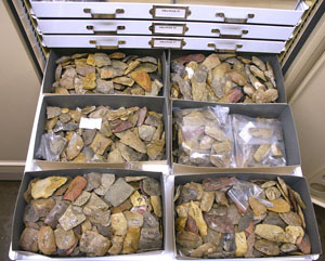
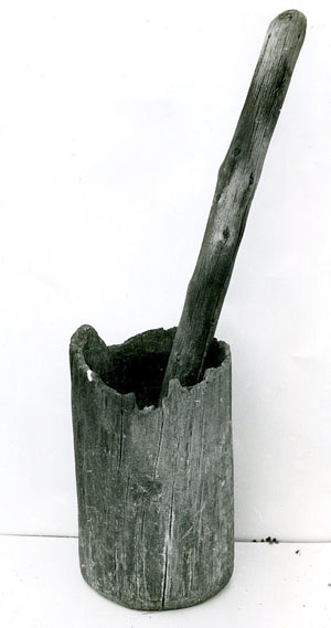
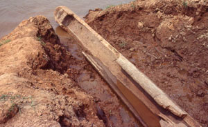
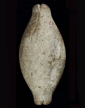
Since humans first set foot there over 10,000 years ago, Morhiss Mound has been cut off from the outside world time and time again by late spring and early fall floods. Sadly, the results of major archeological investigations of the site in the 1930s have also been cut off from the outside world. The half-told story still awaits a proper scientific revisit, with modern analyses of the collections and complete reporting. Yet we can outline the site's significance and offer inferences and speculations based on the intriguing details now known. Morhiss Mound formed on a Pleistocene terrace remnant, a natural high spot amid the thickly wooded bottomlands of the lower Guadalupe River. This particular spot proved to be perfectly situated as a stop-over place for native peoples heading up and down the river. Fairly early in its human history, Morhiss Mound also came to be a final resting place for those whose time had come. And if the prehistoric groups who frequented the site were anything like the 16th-Century Mariame Indians, then we can also guess that during the years when pecan crops were heavy, groups camped here for weeks at a time during the fall. The archeological evidence hints that Morhiss Mound served many different human needs that varied in season, length, and scale. The site's archeological evidence, the knowledge gained from later investigations elsewhere, and basic ecological and hydrological facts allow us to advance reasoned guesses as to some of the hows and whys of life at Morhiss Mound. A better starting place might be the first-hand observations made by the earliest Europeans to spend time along the lower Guadalupe River: two Spanish shipwreck survivors held captive by the Mariame, a native group whose territory probably included the Morhiss Mound stretch of the river. Cabeza de Vaca lived among the Mariame for at least 18 months in 1533-1534 and his countryman, Andres Dorantes, even longer. The resulting Spanish accounts describe the Mariame as living along the lower Guadalupe, mainly downstream from the Morhiss site, for nine months of the year. They were said to move up and down the river in search of deer and other sustenance including fish trapped in oxbow lakes by the spring floods, pecans in the fall, and roots in the winter. As T.N. Campbell has noted, the Mariame are the best known native group in the region in early historic accounts. There are many aspects of the Morhiss site that could be usefully compared against the historic accounts. The prehistoric groups who frequented the site very likely shared much in common with the Mariame and related groups, such as moving between the coast and inland to take advantage of the contrasting sets of resources. We do not yet know how far back in time this inland-coastal territorial pattern may go. The human history of Morhiss Mound began in Early Paleoindian times perhaps as much as 12,000 years ago (10,000 B.C.), based on the finding of a single fragment of a Midland point, a type that dates to Folsom times. These first visitors would have encountered a quite different environment during the waning years of the last Ice Age (Late Pleistocene) and perhaps sought some of the now-extinct animals whose redeposited bones were found at the base of the mound. There is more evidence of a Late Paleoindian presence, including Golondrina and Angostura points, the latter a bit problematic. Elsewhere the Angostura style apparently appears first in Late Paleoindian contexts. For example, Angostura points have been found in deposits dated to between 7000-7900 B.C. at the Wilson-Leonard site near Austin. Within the South Texas Plains, however, the Angostura component at the Richard Beene site near San Antonio has been well dated to 6,800 B.C. at the outset of the Early Archaic. From around 7,000 B.C. onward there is plenty of evidence the Morhiss Mound was visited periodically by native peoples throughout the remaining millennia of the prehistoric era. There is even evidence of 18th century Spanish Colonial artifacts that may have been left by native peoples, such as the Aranama, for whom the nearby missions in Victoria were built. But most of the site's story took place during the 8,000-year span of the Archaic era. Based on similarities of burial customs, bone, shell, and flaked stone tools and technology, and recent analyses of prehistoric health and paleopathology, the inhabitants of the Morhiss site also shared much in common with Archaic peoples across much of the South Texas Plains. That they were hunter-gatherers goes without saying—virtually all native peoples of southern Texas lived by hunting wild game and gathering wild plants until Europeans arrived in the 16th and 17th centuries. But the term "hunter-gatherers" is simply a broad characterization that says little about how specific groups really lived in their own home territories. We can safely assume that those who were buried in Morhiss Mound were members of groups whose home territories included the Guadalupe River Valley in southern Victoria County (and probably much larger areas). Based on a bioarcheological study of the skeletal remains found at Morhiss Mound, those whose home territory included the site had better health and they suffered less trauma (bone-breaking violence) than did Archaic populations in many areas of Texas. These data suggest they had a good diet and a well-established territory. Ongoing nutritional analyses should be able to shed more light on the dietary patterns—did the Morhiss population depend solely on inland resources or, as seems more likely, a combination of inland and coastal foods? See Diet and Health. The presence of marine shell ornaments, tools, and manufacturing debris as well as asphaltum and a few other items shows that those who frequented Morhiss were well connected to the Texas coast. Although these things could conceivably represent trade between inland and coastal residents, it is as likely that the Morhiss inhabitants spent time on the coast as well as along the river. Morhiss is, after all, on the inner edge of the coastal plains and only a few days walk from San Antonio Bay, a trip that could be accomplished in a single day by dugout canoe. Cabeza de Vaca noted considerable seasonal movement of native groups to and fro the coast and inland resources such as the prickly pear fields, which were further inland than Morhiss. We can speculate that one of the reasons that coastal peoples were drawn to the site was to take advantage of inland resources. Among the prime resources would have been the gravel bars and exposures that occur along the Victoria-Morhiss stretch of the Guadalupe. These are among the closest sources of suitable tool-making stones to the San Antonio Bay area. Among the Morhiss artifacts are hundreds of stone tools-in-the-making; in other words, discarded manufacturing failures (thin and thick bifaces and fragments thereof). Of the many relatively thin bifaces, the most likely finished forms would have been dart points and knives. Among the thicker bifaces, there are many that were on their way to becoming adzes. We can also note that the Morhiss stretch of the Guadalupe Valley is and was thick with trees, bushes and vines of many species. The nuts and wood of large trees would have been unavailable along the coast, except for driftwood and live oak. It is probably no coincidence that Morhiss Mound yielded so many stone and shell adzes—woodworking tools. Worked wooden artifacts may have gone hand-in-hand, so to speak, with stone tools as desirable inland resources. When one hears the phrase "wooden artifacts," most of us probably conjure up smallish hand-held things like dart shafts, knife handles, rabbit sticks, atlatls, digging sticks, and so on. But "artifact" just means man-made object. The preponderance of stone and shell adzes begs the question, what were these woodworking tools actually used to make? Adzes can be hafted and used in somewhat different ways for chopping, gouging, and shaping wood, but the most likely targets were relatively large pieces of wood—trees and large limbs. Most of the hand-held tools mentioned above may not have required much more than a sharp piece of flint, even just a large flake, to fashion from a suitable limb or small sapling. Two larger artifacts spring to mind as prime candidates that would have required adzing: mortars and dugout canoes. Wooden mortars were used to pulverize seeds and nuts, a very common food preparation technique for hunter-gatherers. While few such artifacts have survived the passage of time, several have been found in the dry caves of the Lower Pecos Canyonlands. The need for wooden mortars makes very good sense at Morhiss. The lower Guadalupe Valley, the coastal plain, and many parts of the South Texas Plains to the west lack surface exposures of bedrock. This is relevant because bedrock mortars are characteristic of much of the Edwards Plateau and other rocky areas of the state. Given the importance of plant foods in the South Texas Plains, the obvious need for wooden mortars may help explain the preponderance of adzes across the region. But the setting of Morhiss Mound suggests another adze use as well, this one quite speculative. Dugout canoes. We know from many sources that dugout canoes were made across much of the Eastern Woodlands. And we know that some sort of canoes were seen by the Spanish along the Texas coast. The Guadalupe and San Antonio rivers are quite easily navigated by such boats, as attested by the many canoeists and kayakers who use these rivers and their larger tributaries today. We will leave it at that, an intriguing possibility that might help explain one of the reasons that Morhiss Mound had so many woodworking tools. There are also hints that the Morhiss inhabitants, like those buried at Buckeye Knoll, were part of a much broader cultural sphere that extends for many hundreds of miles eastward across the Eastern Woodlands of the United States. The most obvious example are certain of the exotic artifacts, such as the stone pendant and bannerstone made of stones that may have come from the Ozarks or Ouachitas of western Arkansas. These same artifacts and several others are of styles that occur widely further east, and occassionally in the South Texas Plains, mostly in cemetery sites. We don't mean to imply that Morhiss Mound had some special connection to distant peoples, just that the Archaic cultures of the South Texas Plains were part of larger patterns and ideas, the meanings of which we have yet to unravel. Truly, we can not understand how the site fits into both regional and larger cultural domains until more radiocarbon dating is done and particulars of the Morhiss evidence are thoroughly studied. For example, until recently the burials at Morhiss were assumed to represent a Late Archaic cemetery, based on close comparisons among grave goods that have been well documented and dated at other cemetery sites. As it happens, Morhiss Mound is located roughly mid-way between the Loma Sandia site, some 140 miles to the west in Live Oak County and the Ernest Witte site, some 170 miles to the northeast in Austin County. Some of the burial patterns and grave offerings at Morhiss share strong similarities with those known from these large cemeteries that formed mainly during the Late Archaic. It is, however, becoming clear that the Morhiss Mound was used as a burial place long before the Late Archaic. Within the past decade a fascinating Early Archaic cemetery has come to light a scant 5 miles downstream from Morhiss Mound that seems to reflect a previously unknown cultural pattern along the lower Guadalupe. The details of the Buckeye Knoll site have yet to be published, its cemetery has been well-dated by radiocarbon assay to 5400-4300 B.C. Among the distinctive grave offerings there are unusual ground stone artifacts that are similar to several specimens from Morhiss, including the grooved stone artifact on the right. This brings us back to the chronology of the Morhiss site and its history as a burial ground. The ideal approach to dating most prehistoric sites requires charcoal samples from precisely documented stratigraphic contexts that are in close association with time-sensitive artifacts and burials. But in the 1930s, radiocarbon dating had yet to be invented and most of the kinds of samples that are required were not collected from Morhiss. Fortunately, dates can also be obtained from other types of organic materials including bone and progress is being made in pinning down the chronology of the site. The AMS method of radiocarbon dating (Learn More LINK: www.texasbeyondhistory.net/glossary/index.html#r) can be used on very small amounts of organic material. This has made it possible to obtain direct dates on small samples of skeletal remains from Morhiss. Thus far, the only published assay was derived from a small sample from Burial 159 from Morhiss that was reported by Dockall (1997). This burial dates to about 600 B.C., which falls within the later part of the Late Archaic. Recently, professor Robert Hard of the University of Texas at San Antonio has obtained seven additional C14 assays from Morhiss skeletal samples. These new assays are part of an ongoing study on the dietary patterns among burial populations in the Western Gulf Plains that Hard and several colleagues are carrying out. Three of the new assays are said to fall around 5900 B.C. (Early Archaic), two are around 2000 B.C. (Middle Archaic), and one is a Late Archaic date of about 600 B.C. (Hard, personal communication 2006). These new data are quite exciting and provide solid evidence that the Morhiss site was used as a cemetery throughout much of the Archaic era. Our characterization of the Morhiss Mound as representing, in part, a "cemetery" would not be accepted by all archeologists who have worked with other sites in the region with relatively large burial populations. Robert Ricklis, excavator of the Buckeye Knoll site, believes that true cemetery sites are those like Buckeye and Loma Sandia, that seem to have dedicated cemetery areas where little occupational debris occurs. This pattern is distinct from sites like Morhiss, where the burials occur within midden (occupation) deposits. This distinction has considerable interpretive implications. A. J. Taylor, who directed the analysis of the Loma Sandia site, once planned to study Morhiss Mound. She changed research directions, but had made good progress in sorting through, and improving the organization, of the primary documents. Taylor used the WPA records to compile a preliminary map plotting the locations of all the burials and features. Her unfinished working map appears to show at least three major clusters of burials. If these clusters prove to date to different periods of time, they may well be an indication that the site does contain distinct cemetery areas. Evaluating this intriguing possibility is a worthy goal of future research. Cemetery, burial ground, or midden with many burials, Morhiss Mound was a place where peoples were laid to rest with appropriate ritual. Final ThoughtsOf the thousands of archeological sites that have been documented across the South Texas Plains, the Morhiss Mound site, 41VT1, stands out as one of those that should be an extraordinary window on the region's human history. And it may yet. The site's unique setting, its peculiar topography, its prehistory-spanning occupations, its long-lived cemetery, and its fascinating range of artifactual evidence all give it special meaning. It also has a special place in the history of archeological research—the first massive, well-organized, systematic excavation in the region—one that came at a price. The site was completely excavated at a time before modern analytical techniques and needs were known. We cannot go back and excavate it again with state-of-the-art methods and aims. The work at Morhiss Mound was part of a most worthy government program that helped pull the United States out of the Great Depression. The WPA program, however, was ended quickly by foreign affairs, World War II, leaving many ground-breaking archeological investigations unfinished. Since that war archeological scholars have known about the site and its languishing potential. More than a few have dreamed about doing, and even planned to do, something about it. And several researchers who are mentioned in the exhibit have succeeded in studying parts of the Morhiss collection to carry out and complete worthwhile research projects. But seeing a massive excavation through to final conclusion is itself a massive job, one that requires much more time and resources than anyone but a veteran archeologist can truly appreciate. Sorting it all out and putting together the full Morhiss Mound story, is a very daunting challenge. One that done right would require thousands of hours and tens (if not hundreds) of thousands of dollars and the leadership of a first-rate scholar. And as the decades have elapsed since 1940, the task has not gotten any easier. Viewed from ever more modern scientific perspectives, the never-collected data loom as limitations. While most of the primary documentation and most of the collected materials appear to have survived and are being safeguarded for posterity, there are many challenges to working with these. Making sense of notes taken over 65 years ago and of a digging and recording system that was never fully written down to begin with, is anything but easy. Given that the site materials could still tell us quite a lot about the prehistory of the lower Guadalupe Valley, we think the limitations and challenges are well worth overcoming. We predict and hope that one day a determined archeologist will put together the research team and find the resources to see the Morhiss Mound investigations to proper conclusion and tell as much of the story as can be told. In the meantime, professional and graduate-student scholars will continue to make progress, bit by bit, as their own research questions and opportunities allow. Perhaps this exhibit will help set the stage for further progress. |
|
|||||||||||