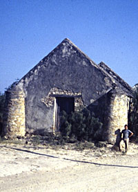
Lopeño, structure built as a residence,
fort, and chapel circa 1820 by Don Benito Ramirez. It is now
submerged, although parts are periodically exposed as lake
levels fluctuate, as shown below. Photo in TARL archives.  |
|
"The frenzied activities of looters have damaged
and destroyed an untold number of sites at Falcon Reservoir,
threatening the very fabric of the prehistoric and historic
cultural heritage of this part of the Rio Grande Valley."
|

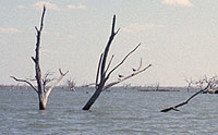
House in Lopeño, partially emerging
from the waters of Falcon Reservoir. Archeologists surveyed
the area as lake levels receded. Photo by Tom Hester.  |
|
The ranchos that were excavated in 1950 and 1951 were
destroyed by the construction of Falcon Dam, and many more sites
like them were soon submerged when Falcon Reservoir was filled.
Falcon Reservoir also covered several hundred prehistoric archeological
sites along the banks of the Rio Grande, as well as two small towns.
In all, an area stretching over 40 miles on both sides of the Rio
Grande was impacted by Falcon Reservoir.
Due to health and safety concerns caused by submerged structures to boaters, the United States Sector of the International Boundary and Water Commission instituted a program of leveling standing structures within the reservoir basin during the 1950s. The program did not anticipate the passage of federal laws designed to protect cultural resources a decade or two later. Most building on the United States side of the reservoir were either dynamited or bulldozed; whereas those managed by the Mexican Sector of the IBWC were left intact. Differences in the management concerns has resulted in the periodic reemergence of churches and structures from the town site of Guerrero Viejo on the Mexican side of lake during low-water episodes, whereas the ruins of ranchos on the United States side appear as mere rubble piles of stone.
During the 1990s, the sites of the Falcon area were
to suffer further destruction. Waters of the reservoir reached record
low levels, exposing hundreds of sites including cemeteries, Spanish
Colonial ranchos, and prehistoric sites that had been submerged
for nearly 40 years. In addition to disturbances caused by pounding
waves and eroding shoreline, the historic and prehistoric sites were exposed to an even more
destructive menace—pillaging by looters and commercial artifact
collectors. Even though most buildings on the Spanish Colonial ranchos were destroyed, many of these sites contain deposits with antique artifacts, and gravesites. All of these remains became open targets for plunderers when the water levels dropped.
In an attempt to assess the damage and determine how
to stop the destruction, a team of archeologists and mapping specialists
from TARL, the Texas Historical Commission, the National Park Service,
the Southern Texas Archaeological Association, and the Texas Archeological
Stewards Network joined together in an unprecedented effort. Their
week-long survey in 1996 along the Falcon shorelines resulted in
the documentation of 40 Spanish Colonial, Tejano, and other sites.
Although the group proposed a comprehensive plan for site protection
to the International Boundary Waters Commission, the damage already
done to the sites was, in some cases, immeasurable.
In their report,
archeologist Dr. Tim Perttula and members of the survey team wrote:
The frenzied activities of the looters and collectors
have damaged and/or destroyed an untold number of archeological
sites at Falcon reservoir, threatening the very fabric of the prehistoric
and historic cultural heritage of this part of the Rio Grande Valley
and calling into question whether the material expression of this
heritage can be preserved and protected for future generations to
appreciate and study.
Today, the reservoir continues to fluctuate
in level, a process which in itself is destructive as sites are
exposed, then resubmerged. Inundation of archaeological remains is detrimental to the preservation of bone, shell, wood and especially metal remains. But the degree of impacts from shoreline erosion caused by wave action associated with fluctuating water levels varies depending upon the slope of the landform, and the site's exposure relative to prevailing winds.
|
|