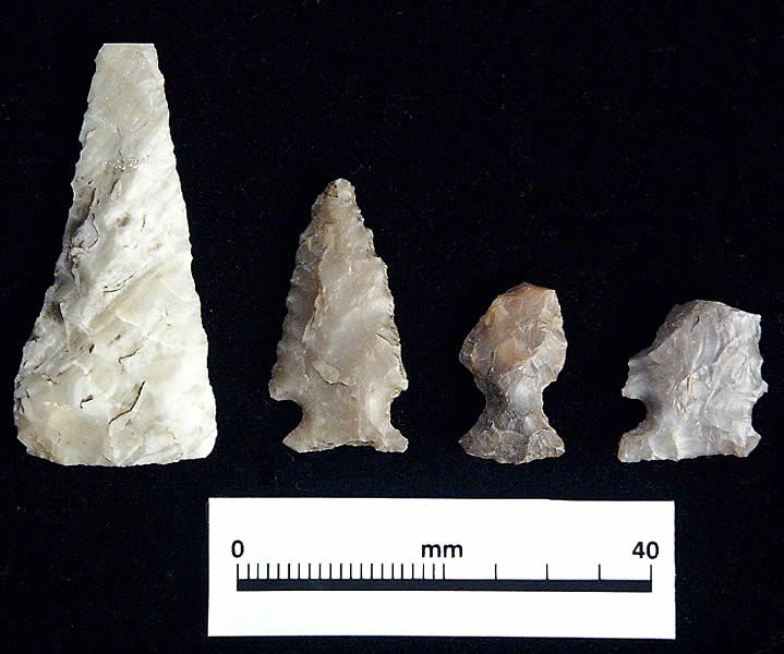
Arrow points, a hallmark of the Late
Prehistoric period (about A.D. 800 to 1600), were among
the chipped stone artifacts found within the middens.
These artifacts were made during the same period that
radiocarbon evidence suggests was the principal period
of midden use. Shown from left are: a triangular arrow
point blank and Scallorn arrow points from the early
part of the Late Prehistoric. Click to enlarge. |
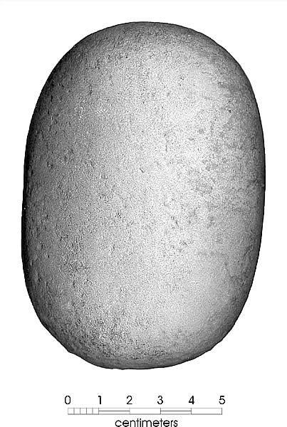
A stone mano from Camp Bowie. These
hand-held tools were used to grind seeds and nuts into
meal. Photo courtesy of CAR-UTSA. |
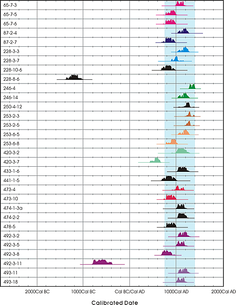
This chart shows the probability
distribution of calibrated radiocarbon dates derived
from 31 samples from Camp Bowie middens. The blue shading
marks the primary time period during which the middens
were used. Graphic by CAR-UTSA. Click to enlarge and
see complete chart. |
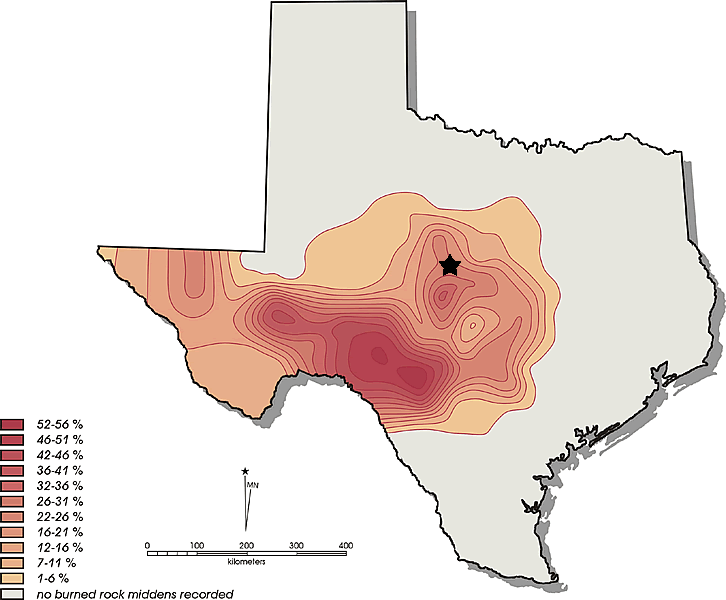
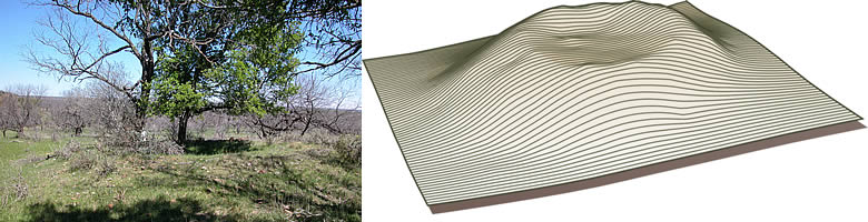
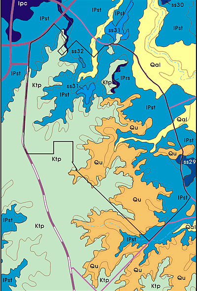
Burned rock midden density across
the state. The relative density by percentage of recorded
middens in counties is shown by color, grading from
peach tone (low) to red (high concentration). The areas
with no middens present are in counties that either
lack burned rock middens or have extremely low percentages
of middens. Black star marks location of Camp Bowie.
Graphic by CAR-UTSA. Click to enlarge. |
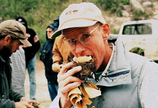
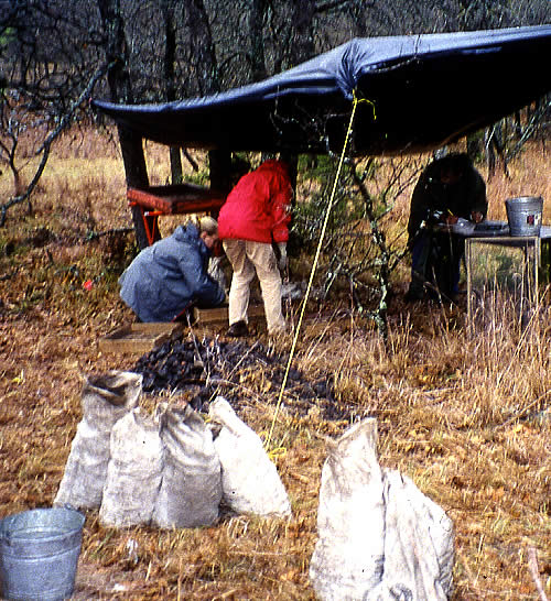
Paleobotanist and archeologist Dr.
Phil Dering, shown sampling the base of a lechuguilla
plant after baking it in an experimental hot rock oven.
Dering, who identified prehistoric plant remains from
the Camp Bowie middens, suggests that sotol and lechuguilla
are the most likely plant foods processed in middens
in the southern section of the Plateau, as well as to
the west. |
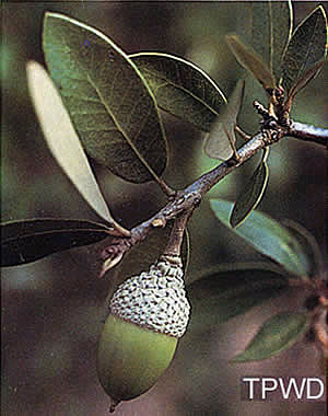
Acorns may have been an important
food resource on the Edwards Plateau. While some researchers
have suggested that burned rock middens represent acorn-processing
stations, the evidence for this interpretation is largely
circumstantial. No ethnographic accounts document the
intensive use of earth ovens for acorn processing.
|
This Ensor-style dart point was found
outside one of middens at Camp Bowie. This style was
made at end of the Late Archaic period just before the
intensive period of midden use in the area began. |
|
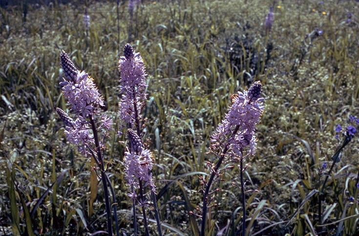
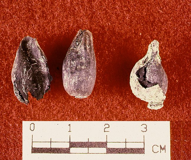
The majority of the identified bulbs were of
eastern camas (Camassia scilloides, also called wild
hyacinth). Central Texas is at the southwesternmost extent
of the historic distribution of eastern camas. Eastern camas
tends to grow in moderately wet areas. Its range may have
extended farther south and west during wetter periods in the
past. The bulbs have the highest nutritional value in the
spring, about the time the flower stalks begin to rise, and
this is likely when they would have been collected. It is
also the time of year when other plant resources are scarce
and most mammals are in poor condition (having burned up stored
fat to survive the winter).
The use of earth ovens to "bulk process"
camas is best known in the Pacific Northwest and northern
Rocky Mountains. Archeologist Alston V. Thoms (now at Texas
A&M) combined early historic accounts and archeological
evidence to show how the native use of western camas (Camassia
quamash) intensified over time. Initial use began
at least 7,000 years ago and the plant became a staple in
the region around 4,000 years ago even though it was a "high-cost"
resource (i.e., one that required lots of labor relative to
caloric return). Thoms linked the intensification of camas
exploitation in the Pacfic Northwest to increasing population
pressure. Texas researchers have applied many of Thoms' ideas
to understanding the burned rock middens of central Texas.
The plant food remains recovered from Camp Bowie
middens are of significance to researchers in Texas and beyond.
According to Dering, the collection is the largest preserved
assemblage of plant food from earth ovens recovered from sites
on the periphery of the Southern Plains. Further, the identification
of the dog's-tooth violet marks the first identification of
this plant from an archeological site. The best record of
its use by historic tribes comes from observations of the
Thompson River Indians in southwestern British Columbia. The
Thompson Indians understood that the raw bulbs of dog's-tooth
violet were poisonous, and they pit-baked the bulbs in order
to remove the poison.
Chipped Stone Tools and Bones
Archeologists found a variety of chipped stone
tools and animal bones at the Camp Bowie sites. In all, however,
only 16 diagnostic artifacts—those representing
distinctive styles known to date to certain time periods—were
found within the middens. These include, from oldest to youngest,
a Middle Archaic dart point, seven Late Archaic dart points,
and eight Late Prehistoric arrow points. With the one Middle
Archaic exception, these diagnostics fall into the same time
periods as the radiocarbon evidence discussed below).
A variety of different types of chipped stone
tools used for butchering animals, scraping hides, chopping
wood, and other daily tasks also were found, along with quantities
of chipping debris left behind by prehistoric tool makers.
Of interest were ground stone artifacts and
features related to food processing—the grinding or pounding
of plants, seeds, and nuts. Hand-held manos, or grinding
stones, such as the one shown at left, would have been used
in combination with grinding slabs, broad stones with shallow
depressions that served as receptacles for nuts and seeds
as they were pulverized or ground into meal.
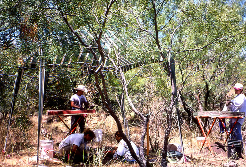
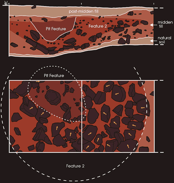
Near one of the midden sites, archeologists
discovered 12 bedrock mortar holes. These deep, circular holes
in flat limestone bedrock have been worn from the pressure
of prehistoric people pounding food with stone or wooden pestles.
The mortars were grouped in clusters of three and nine and
were flanked by two middens. They are roughly 8 to10 cm (3
to 4 inches) in diameter and 6 to 10 cm (2.5 to 4 inches)
deep, although several were as large as 20 to 25 cm (8 to
10 inches) in diameter with depths up to 20 cm. A map showing
distribution of the mortars and middens can be seen by clicking
on the mortar image.
Archeologists also recovered animal bones in
the middens, though they were not common. Bone tends to weather
and deteriorate over time, whether on the surface or buried
in the ground. Among the identifiable bones were those of
white-tailed deer, bison, jackrabbits, cottontail rabbits,
birds, and turtles.
Dating the Middens at Camp Bowie
In addition to determining what the burned rock
middens at Camp Bowie were used for, the archeologists also
wanted to know when the middens were used. The most
reliable dating evidence at most prehistoric sites is radiocarbon
dating. Radiocarbon dates or assays
are statistical estimates of the age of the dated material.
Dates were obtained on 31 samples of charcoal from the middens—most
of the dated charcoal represents fragments of firewood. The
results indicate that most of the Camp Bowie middens were
used primarily during a relatively brief period spanning some
650 years.
The radiocarbon date chart on the left shows
that 28 of the dates fall during the Late Prehistoric period
between A.D. 750 and 1400. A single date falls slightly earlier
at A.D. 600 and two dates fall even earlier, within the Late
Archaic period, at 600 B.C. and 1200 B.C .
The charcoal samples chosen for radiocarbon
dating came from different levels within excavation units
in 17 of the middens. The sampling strategy was to try to
get multiple dates from different levels within the same 1-x-1-m
excavation unit. Whenever possible, the samples were obtained
from units positioned on the midden ring rather than within
the center of the midden. The thought was, if the middens
form from repeated raking out of a central feature, with the
removed material being deposited in the ring, then deposits
located in the ring would likely be less disturbed than those
in the central midden. It was assumed that the central areas
of the Camp Bowie middens had been repeatedly churned up as
earth ovens were built and rebuilt there.
Multiple samples were not available from some
middens and in these cases the archeologists attempted to
obtain samples from the lowest possible level within the midden.
The radiocarbon date chart presents the probability distribution
for each of these 31 (calibrated) midden dates from Camp Bowie.
The dates are grouped by site, and within each site, by increasing
depth. Dates from the same unit within a site are identified
by different color groupings. The samples from sites with
only a single date, or dates from different units within the
same midden, are shaded in black.
There are 10 sites that have multiple dates
from the same unit. These 10 color groupings in the chart
are represented by 23 different dates. In all cases with multiple
dates from different levels the radiocarbon dates form a pattern
as expected, with older dates occurring at increasing depth.
That is, in no case is there a statistically significant reversal
of the dates (such as older above younger). This striking
consistency is somewhat surprising in view of the fact that
many of the charcoal pieces were quite small and could have
moved up or down through the midden by gravity and disturbances
such as tree roots and animal burrows. Given these results,
it would appear that the midden rings gradually accumulated
and were seldom disturbed.
The Distribution of Burned Rock Middens Across Texas
CAR researchers used their understanding of
middens developed from the Camp Bowie data to look at broader
patterns in midden use. Their first task was to look at the
distribution of burned rock middens across Texas. They reviewed
over 9,000 site forms and compiled all site records of burned
rock middens for over 900 sites from more than 50 counties.
These data were combined with an earlier study by archeologist
Darrell Creel (TARL) to produce a data base of over 1,400
burned rock midden sites from 70 counties across the state.
When the density of burned rock midden sites is plotted by
county, the greatest concentration of sites is on the Edwards
Plateau and in southwest Texas.
Because using pit ovens required a great deal
of wood, it also is useful to compare the distribution of
burned rock middens to the distribution of woody vegetation,
especially oak, which is usually the dominate fuel wood found
in burned rock middens (also, charred acorns are sometimes
found in middens). However, because maps only exist for modern
vegetation patterns, the distribution findings are only a
broad indicator of differences in wood types.
The map on the left indicates that the distribution
of burned rock middens within the state is tightly confined,
concentrated primarily on the Edwards Plateau and in west
Texas. Comparisons of midden distribution with plant distribution
patterns (map on right) shows that, while the distributions
of oak and middens partially overlap, there are high densities
of middens found well southwest of the Edwards Plateau, in
areas where oaks are uncommon. It could be argued that a slightly
expanded prehistoric distribution of oak-dominated settings,
to the southwest and to the west, could accommodate as much
as half of the overall distribution of burned rock middens.
Nevertheless, even if we equate oak presence
with acorn processing, it is unlikely that oak accounts for
the entire distribution of burned rock middens. The distribution
to the west and southwest of the Edwards Plateau is clearly
not associated with oak, and by extension, clearly not associated
with acorn processing. Archeologists such as Glenn Goode and
Phil Dering have suggested that sotol and lechuguilla are
the most likely candidates for processing in burned rock middens
in the southern section of the Plateau, as well as to the
west, where sotol and lechuguilla are more common. A number
of ethnographic accounts document the use of these plants,
processed in earth ovens, throughout New Mexico, Northern
Mexico, Arizona, and into California. In addition, charred
agave has been recovered from earth ovens and middens in southwest
and far west Texas.
While the northern and eastern distribution
of burned rock middens coincides with oak-dominated vegetation
and could be correlated with areas of prehistoric acorn processing,
the area also lies within the southwestern end of the distribution
of geophytes (second map on right). Unlike oak wood, geophytes
could not have been used as a fuel resource and clearly were
being used for food, as indicated by their presence in the
Camp Bowie middens. While the idea that acorns were being
processed at burned rock midden sites cannot be entirely ruled
out, the fact that oak is the major wood identified in Central
Texas burned rock middens suggests that the occasional charred
acorns found in middens may simply represent incidental burning
associated with the use of oak fuel wood.
If geophytes—bulbs—rather than acorns,
were the focus of most middens in north-central Texas, why
are there no middens to the north? Eastern camas distribution,
for example, continues to the north, and other geophytes are
certainly in this northern section of the state also. The
distribution of oak continues to the north as well. We have
food and fuel, why don't we have middens? At present, archeologists
have yet to seriously address that question. We can suggest,
however, that if we are correct about geophytes, then the
answer probably lies in considering alternative resources.
Geophytes are "low return" resources,
they require a lot of work for the amount of nutrition they
provide, and potentially were used only for a limited time
during the early spring. We suspect that to the north other
plant resources may have been available that reduced the importance
of geophytes. At present, however, we have no suggestions
as to what these alternative resources might have been. The
absence of burned rock middens in many areas can be explained
by the lack of suitable rock. Earth ovens can be built without
rocks, but they may be harder for archeologists to recognize.
The southwestern distribution of burned rock
middens probably reflects the use of lechuguilla and sotol,
since it is unlikely that high densities of geophytes ever
were present in this relatively dry region. Counties with
the highest percentages of burned rock middens seem to be
on the border between the areas to the west, probably associated
with sotol and agave processing, and the areas to the north.
While these higher percentages might reflect both processing
of sotol and acorns, we would suggest that sotol, lechuguilla,
and geophytes are a more likely mix.
Summing It Up
Between A.D. 750 to 1400, Late Prehistoric peoples
repeatedly came to the Camp Bowie area to process large quantities
of bulbs in earth ovens heated by hot rocks. As favored oven
pits were reused over successive visits, burned rock middens
formed at many places on the landscape.
The radiocarbon evidence suggests several periods
of intensive use, separated by periods of lower use frequency.
These patterns may be related to fluctuations in the availability
of what was being processed in the middens, fluctuations in
availability of wood resources, more general changes in settlement
and subsistence, or a combination of these and other factors.
We believe that patterns in fuel wood resources
are a critical component in understanding patterns of midden
reuse. Because wood collecting was so labor intensive and
because wood resources would have been locally depleted over
time, the pit ovens may have been abandoned periodically until
the area's trees had time to rejuvenate.
In addition, the differential distribution of
these fuel wood resources may help to account for the strong
association of burned rock middens with oak, an association
that has previously been seen as related to the use of acorns.
Considering the spatial distribution of burned
rock midden sites across the state, it is likely that two
different sets of plant food resources (sotol and geophytes),
each with different spatial distributions, might be the major
food resources processed in middens within the state.
There is a strong likelihood that the Camp Bowie
middens were ovens where geophytes were processed. Over hundreds
of years, prehistoric people traveled to the area to harvest
and process bulbs, particularly camas— the principal
resource—during a short seasonal window of time, in the
early spring. The evidence of their culinary handiwork still
remains in the numerous burned rock middens and in an array
of other data.
Managing Camp Bowie's Cultural Resources
Fourteen of the Camp Bowie burned rock midden
sites were determined eligible for the National Register of
Historic Places. For National Guard training purposes, these
sites are considered "sensitive environmental areas"
and are officially "off limits." These areas are
monitored regularly by TXARNG training site managers and TXARNG
cultural resource staff to ensure that they remain undisturbed.
In the event that training activities or military construction
threatens to impact any of these sites, the state historic
preservation office (Texas Historical Commission) as well
as the Native American tribes that historically lived on what
is now Camp Bowie would be consulted and a reasonable compromise
would be sought among the various interests.
Through the cultural resource management process,
the Texas Army National Guard is able to continue its training
programs at Camp Bowie to help ensure national security, while
minimizing the loss of important historic information. This
balanced consideration is precisely the outcome envisioned
by Congress when the National Historic Preservation Act was
passed in 1966.
|
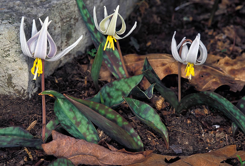
White dog's-tooth violet in bloom,
a similar variety to the type recovered from a Camp
Bowie midden. The finding of the prehistoric specimen
of this bulb in an archeological context was a first
in North America. Photo by Thomas G. Barnes, USDA-NRCS
PLANTS Database. Click to enlarge. |
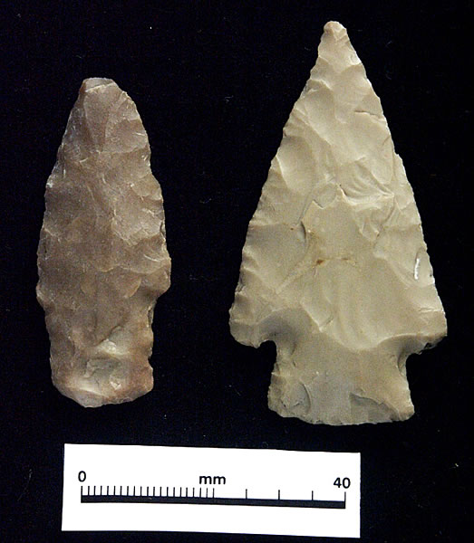
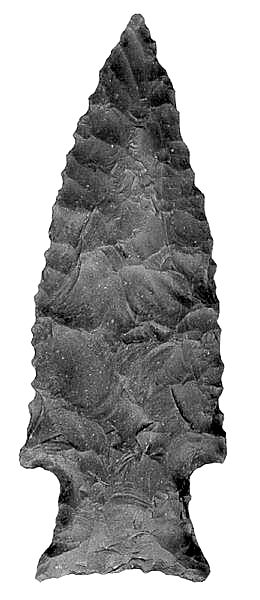
Late Archaic dart points were the
other midden artifact types useful in dating the middens.
Two radiocarbon samples also fell within the Late Archaic
period, at 600 B.C. and 1200 B.C. The dart on left has
the tell-tale "pot-lid" fractures and pinkish
coloration derived from burning; it may have been inadvertently
included within the earth used to cap the ovens. |
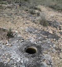
This bedrock mortar, one of 12 discovered
in a cluster at Camp Bowie near two burned rock middens,
likely was used with a pestle for pounding foods such
as seeds or nuts. Photo courtesy of TXARNG. Click to
see distribution map of middens and mortar holes. |
| FAQ: What are
the Archaic and Late Prehistoric periods?
The Archaic period or era is a
very long span of human history in North America that
began about 9,500 years ago (7,500 B.C.) and lasted,
in the Camp Bowie area, until about 1200 years ago (A.D.
800). The Archaic concept was originally conceived ...
>>read
more<< |
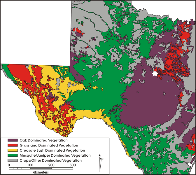
Wood vegetation across central and
west Texas. The area in purple is predominately oak;
the green area is mesquite-juniper. This map, a simplified
compilation of various modern distribution maps, is
not an accurate reflection of prehistoric patterns which,
over time, were dramatically altered by both climate
change and radical changes in land-use practices during
the last 125 years. Nevertheless, the map provides some
indication of large-scale differences in distribution
of wood types . White star marks Camp Bowie location.
Click to view full map. |
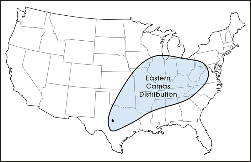
Camas distribution across the United
States. Eastern camas still grows in central Texas,
but it was probably much more common during certain
times in prehistory when the climate was more moist.
Most of the bulbs found in Camp Bowie middens were of
this species. Black star marks Camp Bowie location. |
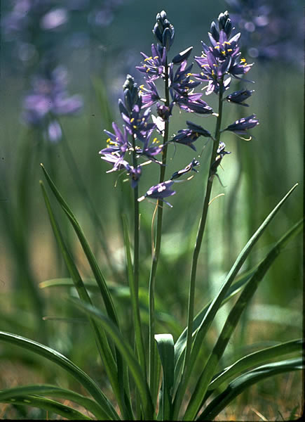
Common camas (Camassia quamash) in
flower. These grow primarily in the northwestern United
States and have been found in archeological sites there
as well. Photo by William and Wilma Follette. |
|
Fourteen of the Camp Bowie burned rock midden sites
were determined eligible for the National Register of
Historic Places. For National Guard training purposes,
these sites are considered "sensitive environmental
areas" and are officially "off limits."
Through the cultural resource management process, the
Texas Army National Guard is able to continue all of
its training programs at Camp Bowie to help ensure national
security, while minimizing the loss of important historic
information. |
|