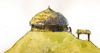
Artist's depiction of a Caddo temple
mound with structure on top, sacred places where Caddo
priests conducted ceremonies. Painting by Charles Shaw.
Click images to enlarge
|
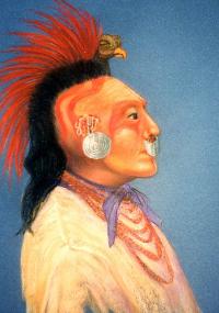
A Caddo man in bird headdress as
visualized by artist Reeda Peel. The painting is based
on a description of Caddo men in state dress for a meeting
with General Manuel Mier y Teran, who headed a Mexican
boundary commission sent by Santa Anna in 1828. Painting
courtesy of the artist.
|
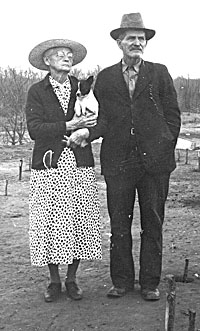
Mr. and Mrs. A.J. Hatchel (holding
JoJo) standing atop the major temple mound on their
farm, circa 1938. Photo from TARL archives.
|
|
When French and Spanish explorers in the sixteenth and seventeenth centuries ventured into the Southeast and the area that is now Texas, they passed through many communities of Caddo peoples. Their accounts tell of peaceful hunting and farming folk led by stately chieftains, villages with thatch-covered houses, and patchworks of fields planted with crops. Some of the travelers saw large flat-topped mounds topped with structures, dominating the landscape like small hills. Although elaborate ceremonies were conducted from their lofty heights, after ca. A.D. 1691 the mounds no longer saw the cycles of building and renewal that had marked earlier times. By the time of continuous contact between Europeans and Caddo peoples in the late 17th century, the mound-building tradition had effectively ceased.
In the country of the Caddo, the Spanish and French competed fiercely for the loyalty of the native peoples. Enterprising French traders established posts among the Kadohadacho and Hasinai groups and set up a lucrative exchange, trading guns, glass beads, kettles, metal tools for scraping animal hides, and horses provided by the Native Americans. Spanish priests, finding the people to be "peaceful, gentle, and jovial," established missions among the more southerly Hasinai peoples with the intent of assimilating and converting the Native Americans and using them as a bulwark against French encroachment. While the Spanish offered only religion—which the Caddo already had—the French brought the much more desired objects: guns.
At the Great Bend of the Red River were the
villages of the Upper Nasoni Caddo, a name appended to both
the people and the location by the French. This sprawling
community—some have estimated it stretched for more than
8 kilometers in length—saw its share of Anglo-European
visitors. Remnants of the De Soto expedition may have passed
through as early as 1542, followed by Henri Joutel in 1687.
The Teran expedition, led by Domingo Teran de los Ríos,
traveled through in 1691-1692.
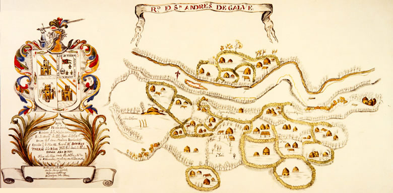
Significantly for researchers today, a detailed
map of the village was generated from that latter venture.
As shown above, it depicts dispersed clusters of small farmsteads,
each containing several buildings, ramadas for shelter, and
above-ground granaries. On the west side of the village, there
is a mound shown with a structure marked "Temple,"and
near the center, the house of the Caddi, or chief.
Some 30 years after Teran passed through the
community, French trader Jean-Baptiste Benard, Sieur de La
Harpe set up a small trading post among the Upper Nasoni people people in the area of the Roseborough Lake site (41BW5).
He had been warmly welcomed by a delegation of chiefs, and
in short measure, a relationship was established. In exchange
for the European goods that La Harpe brought, the villagers
provided a choice spot for his concession on the lands of
the chief.
The Frenchman found the locale and people exemplary:
"…the country is fine, the earth black, and the
prairies most beautiful and fertile." Men and women
worked the fields, growing corn, beans, watermelons, sunflowers,
and other small crops. They hunted the verdant woods and prairies, supplementing their diet with wild foods and game. They crafted distinctive pottery vessels, some artfully decorated with engraved and trailed spiral designs and animal-headed handles on effigy bowls. And they engaged in trade with the Europeans. But this way of life was to change drastically, as the native peoples were afflicted with diseases carried by the newcomers. With cruel rapidity, the village population diminished. In 1806, members of the Freeman-Custis expedition, who were surveying lands for the Louisiana Purchase, traveled past the Upper Nasoni village and found it abandoned.
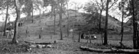
Roughly 125 years later, archeologists from
the University of Texas-Works Progress Administration program
began excavations at a large mound on the Northeast Texas
farm of Mr. and Mrs. A. J. Hatchel. At the mound and in the
adjacent fields, they unearthed a complex record of occupations
spanning more than 650 years. A cemetery containing more than
60 graves from several periods of use as well as remains of village areas were investigated
on sites nearby. Because this cemetery was being looted when
the work began, the WPA archeologists thought it best to salvage
what information they could. The locale, known to archeologists
as the Hatchel-Mitchell-Eli-Moores complex, came to be recognized
as one of the most important Caddo sites in Texas.
But the mound and its surrounding village areas
were to take on a greater significance. Through the painstaking
research of ethnohistorian Mildred Mott Wedel and others,
this enormous archeological complex was identified as the
Upper Nasoni village visited by the early travelers and known
previously only through their records, maps, and drawings.
There La Harpe had traded his wares on the land of the chief;
on the mound had stood the awesome structure where religious
and political leaders conducted their rituals. By poring over original documents
(rather than poorly made translations) and ground-testing
distances recorded by La Harpe, Wedel was able to link the
location of the village to the historic documents. With this
critical correlation, we are now able to examine late-period
evidence from the archeological site in the context of those
historic accounts, providing a much fuller and richer image
of the Upper Nasoni village as it neared its demise.
The section following offers a look at WPA
excavations at the site through a gallery of archival photos
from that undertaking.
|
Teran map cartouche, or key. One
translation reads in part: "This new discovery
of the Caddudacho Nation was...made by General Don Domingo
Theran de los Rios, Lt. Gen. of all New Spain, in the
year 1691. This visit was made in the said section and
province on the 28 of November with only thirty men,
in the said year."
|
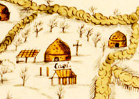
Closeup of Teran map depiction of house of the Caddi,
or chief, at the Upper Nasoni village, circa 1691. |
WPA excavations on mound at Hatchel
site. Photo from TARL archives.
|
| |
|
Through the painstaking research of ethnohistorian
Mildred Mott Wedel and others, this enormous archeological
complex was identified as the Upper Nasoni village visited
by early travelers and known previously only through
their records, maps, and drawings.
|
|