|
FAQ: How and
why are archeological sites "recorded?"
Recording an archeological site involves
filling out a site survey form.... read
more>>
|
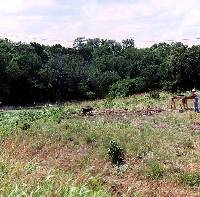
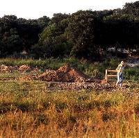
Initial excavations underway on
the north side of highway. Note the pool of water
in Leon Creek.
|
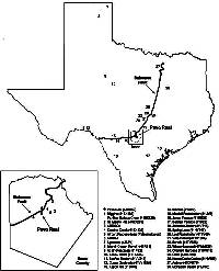
Map showing location of Pavo Real
and select other important Paleoindian and Archaic
archeological sites in Texas.
|
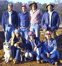
Archeological crew during excavation
of the Paleoindian component at Pavo Real. Top row,
left to right: Bob Stiba, Darrell Creel, Glenn Goode,
and Marshall Eiser. Bottom Row, left to right: Barbara
Baskin and dogs, Margaret Hausauer, and Jerry Henderson.
|
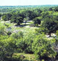
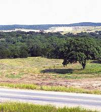
View south from Pavo Real across
the rolling terrain below the Balcones Escarpment.
To the south across the Gulf Coastal Plain, the natural
vegetation is dominated by thorny brush adapted to
hot, dry conditions.
|
| |
|
FAQ: What exactly
is a hearth?
The generally circular "beds"
or arrangements of cooking rocks that once formed....
read more>>
|
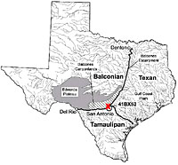
Site location relative to major
physiographic and biotic provinces of Texas. Click
for larger view.
|
View early in the investigations
of the western edge of the area that would become
the main focus of excavation. Note dry bed of Leon
Creek in background.
|
| |
Excavations in progress, fall 1979,
view looking northwest.
|
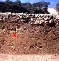
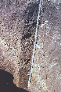
Excavation wall profile at Pavo
Real. The layer of rocks at the top is the outer edge
of a burned rock midden (Feature 4). The Paleoindian
deposit is marked by the red X. Elsewhere in the site
the two gravel layers above and below the Paleoindian
layer were more distinct.
|
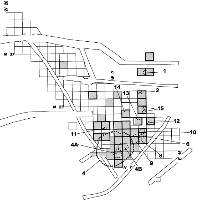
Plan map of main excavation areas
at Pavo Real. The trenches were dug by machines. Among
the hand-dug squares, those shaded gray show the Archaic
excavations. The Paleoindian excavations covered all
of the squares. The dashed and numbered areas show
the location of the Archaic features. Click to enlarge.
|
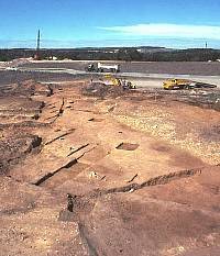
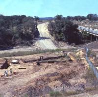
View of excavations near the end
of the field work as seen from cherry picker. Highway
construction is in progress in the background.
|
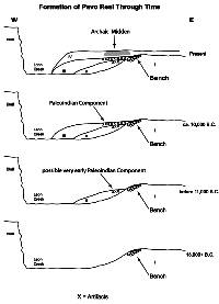
Schematic depictions of a cross-section
through the Leon Creek Valley at Pavo Real, showing
how the site formed through time. This reconstruction
is based on the geological evidence.
|
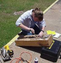
Twenty years after the soil monoliths
were boxed up and stored away, micromorphologist Heidi
Luchsinger of Texas A&M University carves out
small samples from which she will create thin sections
for microscopic examination. Micromorphology is the
study of sediments under a microscope to understand
how sediments and archeological deposits formed.
|
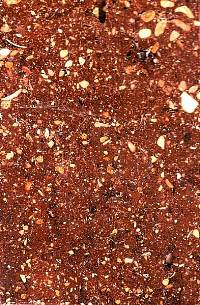
Consolidated sediment block removed
from the Zone 5 layer in one of the soil monoliths.
This 2-x-3 inch block shows that the Zone 5 sediment
became coarser and less compact toward the top of
the zone. The black tic marks at the top indicate
that the block is oriented correctly (i.e., top is
nearest the surface and toward the top of Zone 5).
Photo by Heidi Luchsinger.
|
|
Pavo Real was first recognized and recorded
in 1970 by two high school students, Bill Fawcett and Paul
McGuff, long after the original two-lane highway 1604 had
been built across Leon Creek. They had found the site after
TxDOT cleared a new, much wider right-of-way in anticipation
of expanding the road into an eight-lane thoroughfare. The
two students were searching the area for archeological sites
because they could see that subdivisions, roads, and shopping
centers would soon obliterate most traces of the many prehistoric
campsites present in northern Bexar County. They hoped the
information they recorded would be of use, as indeed would
prove to be the case. (Fawcett and McGuff both went on to
study archeology in college and become professional archeologists.)
The original site record was brief and noted
the presence of "fire pits" near the creek that
had created "a rise above the rest of the site."
On the surface it appeared similar to many other poorly
known sites in the area—just another seemingly unremarkable
place where prehistoric people had left behind evidence
of camping and tool making. A few years later, Dr. Thomas
R. Hester, then professor of anthropology at the new, nearby
campus of the University of Texas at San Antonio, visited
the site and recognized that the site might have deeply
buried deposits dating back to at least the early part of
the Archaic period. Hester alerted TxDOT archeologists to
the site's potential and urged the agency to investigate
the site prior to the construction of the highway.
In the late 1970s, federal and state laws
and regulations governing cultural resources were
in place, but the field of contract or cultural resource
management (CRM) archeology was still young and the "standard
operating procedures" were not yet standardized. Because
some of the funding for the highway expansion came from
the federal government, the impact of the construction on
potentially important "historic properties" (such
as archeological sites and old buildings) would have to
be considered under the National Historic Preservation
Act of 1966. Because site 41BX52 lay unalterably in
the path of the planned highway, TxDOT archeologists began
to evaluate the site's significance by carrying out test
excavations.
Before discussing the investigations further,
let's take a look at what archeologists call the "site
setting" of Pavo Real.
Site Setting
The general location of the Pavo Real site
figures prominently in the region's historical landscape
as well in as San Antonio's modern transportation network.
As part of it's unique natural setting, the site was located
on or near important but little known historic and, very
probably, prehistoric trails. The valley of Leon Creek,
which heads (begins) only 22 kilometers upstream from the
site, forms a natural corridor linking the Hill Country
of the southern Edwards Plateau, the Blackland Prairie to
the east and the Gulf Coastal Plain to the south. The site
is located within the Balcones Fault zone just below the
Balcones Escarpment, once known as the margin of Apachería
and Lomería Grande. The edge of the Edwards Plateau
is also known as the Balcones Canyonlands because of the
many deeply entrenched streams and rivers that drain the
plateau.
Historically, an old trail ran through the
natural pass formed by the Leon Creek Valley and linked
Bexar (modern San Antonio) and a Spanish Colonial presidio
popularly known as San Sabá (Presidio San Luis
de las Amarillas) in present-day Menard County. Early
settlers called this pass, la puerta (de las casas)
viejas (roughly translated as, "gateway
to the old houses" or "old pass"). The nearby
pass and the immediate vicinity of the Pavo Real site became
a documented Comanche trail leading northward from the springs
of San Pedro Creek in San Antonio. In the early history
of the settlement, the historical trail also may have been
called the camino de tehuacanas (an apparent reference
to the Tawakonis, a Wichita group commonly associated with
north-central Texas throughout the 18th century). By the
mid-19th century, this ancient trail became a major route
of German immigration from San Antonio into the Hill Country.
Today, the vicinity of the Pavo Real site
is the intersection of two major regional thoroughfares.
Interstate Highway 10 passes through the Leon Creek Valley
following the same basic route as the historical trail and
today, a few hundred years east of Pavo Real, carries an
average of about 181,000 vehicles per day. Loop 1604 West
runs along the Balcones Escarpment and today it carries
some 162,000 vehicles daily over Leon Creek and the former
location of the ancient campsite.
In addition to Pavo Real's location on a natural
corridor, three other factors help explain why prehistoric
peoples stopped to camp at Pavo Real: water, chert, and
ecotone. Leon Creek itself would have had water it
in year-round, even during droughts, at least in its deeper
holes. Until the early 20th century, Leon Springs (10 kilometers
upstream) and three other minor springs flowed freely (since
the early 1900s, groundwater pumping has severely reduced
or halted the flow of all springs in northern Bexar County).
Today very little water flows in Leon Creek except at times
of significant rainfall when it is subject to flash flooding.
The finding of water snails in the site's Paleoindian deposits
hint that there was a permanent pool of water at or near
the site early in its history. The relatively well-watered
valley would have provided habitat for many of the plants
and animals upon which prehistoric peoples depended.
The site area also has an abundance of chert,
the hard silica-rich rock often called "flint"
that prehistoric peoples used to fashion projectile points
and many tools. Chert seams are visible in the limestone
bluff opposite the site, cobbles and fractured chert pieces
are common in the gravel bed of Leon Creek, and, most importantly,
chert was available on the site along a natural limestone
bench that was exposed in Paleoindian times. The chert present
along the bench ranged from pebbles to small boulders up
to 40 centimeters (about 16 inches) across. As chert goes,
the local material is not of a particularly high quality.
It is highly weathered (turning it white and eventually
soft and chalky), often fractured, and sometimes contains
internal masses of a harder chert that makes flint knapping
difficult. Most of it is white to gray in color. Despite
its uneven quality, the Pavo Real chert was used intensively
by the Paleoindian groups who camped at the site and less
intensively by later Archaic peoples.
The third factor is that the site is located
along a broad ecotone or zone of mixed plant and
animal communities sharing characteristics of the Edwards
Plateau (Balconian biotic province) to the north, the Blackland
Prairie (Texan biotic province) and the Gulf Coastal Plain
(Tamaulipan biotic province) to the south. North of the
site, the plateau is rocky, hilly, and has mostly thin soils.
The vegetation is drought-resistant oak-juniper savanna
on uplands and slopes with hardwood forests in the better-watered
canyons and valleys. Along perennial streams are found cypress,
pecan, willow, and other trees dependent upon abundant water.
Among the streams and rivers that form the Balcones Canyonlands,
Leon Creek is rather small and intermittent. Not far east
of the site is a narrow band of the Blackland Prairie, which
was originally dominated by tall grasses. South of the site,
is the expansive Gulf Coast Plain, which is covered mainly
in drought-resistant thorny scrub brush and grasses except
along streams.
In summary, the Pavo Real site was located
on a natural transportation corridor in a location that
provided prehistoric peoples with convenient access to the
basic necessities of hunting and gathering life: water,
tool-making materials (chert and wood), plants and animals.
But don't get the wrong idea—Pavo Real was not a particularly
idyllic or favorable spot, it was just in a general location
that had lots of things going for it. There are (or were)
dozens of other prehistoric sites located along this stretch
of Leon Creek, some of them were probably more-favored spots,
to judge by the relative quantities and densities of refuse.
Many major prehistoric occupation sites occur along the
Balcones Escarpment, especially at the major springs and
along the larger streams and rivers. At times of drought,
the Balcones Canyonlands may have served as critical resource
areas because of the permanent water and wealth and diversity
of other natural resources.
Investigations
When TxDOT archeologists began to investigate
Pavo Real, they thought it was a typical Archaic campsite,
as it indeed proved to be (in part). Archeologist Jerry
Henderson was placed in charge of the fieldwork assisted
by Glenn T. Goode and several other TxDOT archeologists.
Initial backhoe testing in late May 1979 revealed the presence
of several shallowly buried middens and deeper deposits
suspected to date to the Early Archaic (about 7,000-9,000
years ago). As the TxDOT work progressed, the Archaic deposits
at 41BX52 were found to include at least one well-developed
burned rock midden (Feature 4) as well as several smaller
middens, all located along the terrace edge nearest the
creek. A hearth field of undetermined extent occurred in
the vicinity of the annular (ring-shaped) midden, the only
area of the site where the Archaic deposits were sampled
reasonably well.
Following the backhoe trenching in May, 1979,
the TxDOT archeologists began hand excavations at Pavo Real
to examine the middens and dig below them in hopes of finding
an Early Archaic component. [Most burned rock middens date
to the Middle Archaic period (about 5,000-7,000 years ago)
or later. The lifeways of earlier Archaic peoples was very
poorly known in the late 1970s and was the subject of considerable
interest.] For most of the summer of 1979, the archeologists,
aided by local TxDOT workers opened up a series of small
excavation units, mostly 2-x-2 meter squares, in different
parts of the site. They concentrated most of their effort
in and around the site's largest burned rock midden (designated
Feature 4).
By mid-August time was running out; fieldwork
was scheduled to be completed before the end of August.
Thus far the site hadn't turned up much that was particularly
interesting or different from previously excavated sites.
It was a typical burned rock midden site dating mainly
to the Middle and Late Archaic periods with some evidence
of Early Archaic occupation. But preservation conditions
were poor—almost nothing was found except burned rocks,
dart points and other chipped stone tools, and lots of tool-making
debris. In a few cases some charcoal was found in some of
the hearths that might yield radiocarbon dates.
Friday August 17th would be the last day for
the local workers, and the Austin-based archeologists expected
to wrap things up the following week. It was apparent that
many of the excavation units could not be completed within
the remaining time. Then, unexpectedly, a Clovis point
was found on August 15th within what had previously
been considered an Early Archaic deposit (only 45 centimeters,
or 18 inches, beneath the surface). This find was potentially
important because Clovis sites were rare—was this an
isolated find?
The archeologists were given a several-week
extension to determine whether intact Paleoindian deposits
were present. By late September they had found a Folsom
point and other early artifacts and determined that an isolated
Paleoindian component was present, sandwiched between two
gravel lenses. A Gradall (a large precision-digging machine
often used in highway construction) was then brought in
to remove most of the remaining Archaic deposits north and
east of Feature 4. Despite continued pressure to hurry up
and finish the dig so that highway construction could proceed,
the dig was extended by several months to investigate the
Paleoindian materials.
The second half of the dig, from October,
1979, to January, 1980, concentrated exclusively on the
site's Paleoindian component, which rested in a sandy layer
between two gravel lenses. Henderson was still in charge
of the work, but additional experienced professional archeologists
were hired on to help. At the time, the archeologists thought
the early materials dated mainly to the Folsom period and
so they called the sandy layer the Folsom zone. To
investigate the zone, they laid out a series of 2-x-2-meter
squares that systematically covered most of the area (in
contrast to the spotty approach taken with the Archaic dig).
Instead of digging using mainly shovels, as was done with
the Archaic dig, they dug mainly with trowels and carefully
plotted the locations of many of the artifacts they found.
In addition to the archeological dig there
was also geological work done to try and understand how
the Paleoindian component formed. This mainly consisted
of using heavy machines to dig deep, but narrow, trenches
through various parts of the site followed by detailed geological
recording. Unfortunately, the geological work was not coordinated
with the archeological work, resulting in several missed
research opportunities. For example, the deposits identified
geologically as those most likely to show stratigraphic
separation between Clovis and Folsom occupations were not
targeted by the archeological excavations. Another missed
opportunity was the chance to effectively sample a deeply
buried deposit beneath the main Paleoindian deposit. Flint
flakes (tool-making debris) were found in a deep geological
test, but this was not followed up by excavation. These
materials could date to earliest Clovis times or possibly
even earlier.
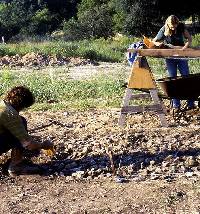
One very far-sighted thing that did come from
the geological work was the taking of four soil monoliths.
Archeologist Grant Hall from the Center for Archaeological
Research at nearby UT-San Antonio lent his expertise in
this effort. Soil monoliths are columns of sediment that
were carved out of the walls of some of the trenches, solidified
with a plastic resin, wrapped in burlap, and then encased
in wooden boxes built around the columns. The accompanying
photographs show how this was done. Such samples provide
"witness columns" of intact sediments for future
studies. And, in fact, archeologists and soil scientists
20 years later were able to take samples from the archived
Pavo Real soil monoliths and apply sophisticated new analytical
techniques to study how the site formed and to date the
site's deposits.
After the Pavo Real dig ended in early 1980,
the materials were processed in TxDOT's archeological laboratory
and Jerry Henderson began initial analysis. Unfortunately,
other agency priorities intervened, personnel changed, and
the project remained uncompleted for two decades.
In 2000, archeologists from the Texas Archeological
Research Laboratory began to analyze the Pavo Real materials
under contract to TxDOT. Noted Paleoindian expert and geoarcheologist
Michael B. Collins directed the studies of the Paleoindian
materials. Pavo Real's Archaic materials were studied by
Steve Black, who had directed the excavation of another
Archaic burned rock midden site in northern Bexar County,
the Panther Springs Creek site, in 1979-1980 while the work
at Pavo Real was underway. Dale Hudler managed the project
and undertook a variety of special studies of projectile
points and other materials. Expert consultants were called
in to do other specialized studies, particularly those of
the soil monoliths. The work was completed in 2003, culminating
in a thorough scientific report and this web exhibit.
|
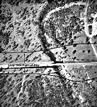
Aerial photograph showing site
vicinity as it appeared at the time of the 1979 excavations.
Note the sharp bend in Leon Creek just upstream (north)
of Pavo Real (41BX52).
Click images to enlarge
|
Archeologist Jerry Henderson during
the initial analysis phase in 1980. Unfortunately,
other priorities intervened before the analysis could
be completed and the site materials remained unstudied
for another 20 years.
|
View north from Pavo Real of the
Balcones Escarpment. The large limestone quarries
visible have provided building material for the growth
of San Antonio. Beyond the escarpment lies the Edwards
Plateau.
|
| |
Initial excavations underway on
south side of highway. Here the top of a "sheet"
midden, or thin burned rock accumulation, is being
exposed. Leon Creek is in the background.
|
|
FAQ: What is
a burned rock midden?
A burned rock midden (BRM) is basically
a refuse accumulation of fire-fractured cooking rocks
("burned rocks") that.... read
more>>
|
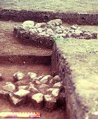
Two hearths uncovered in the Archaic
deposits at Pavo Real. The one in the background,
Feature 6, was a little over 4 feet across, while
the nearest one measured about 2.5 feet across. Such
small to medium-sized hearths are probably the heating
elements of small earth ovens.
|
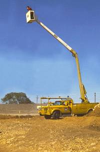
The many excellent overhead pictures
of the Pavo Real were taken from the bucket of a "cherry-picker"
truck. Field director Jerry Henderson also served
as project photographer.
|
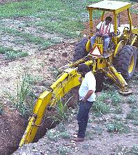
Geological trenching in progress
at Pavo Real in 1979. Geologist Chuck Johnson monitors
the progress.
|
Here one of the deeper soil columns
has been isolated to prepare it for being jacketed
and stabilized as a soil monolith.
|
|
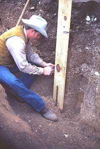
Archeologist Grant Hall trims
the soil column before adding more boards.
|
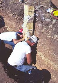
Archeologists work to free the
soil monolith, now surrounded on three sides by boards,
from the excavation wall. Once free, a fourth board
will be added to create a protective box for the monolith.
|
|
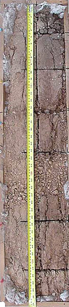
Here is one of the soil monoliths
from Pavo Real, 20 years after it was boxed up and
stored. The darker soil at the top of the column is
that of the Archaic deposits. The Paleoindian layer
is just below the thick layer of gravel visible about
mid-way down.
|
|