|
In this section:
|
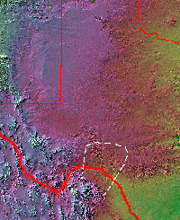
The approximate boundaries of the
Lower Pecos archeological region are shown in white
on this shaded relief map. Its southern extent is unknown
but believed to lie in the Burro Mountains of northern
Coahuila. Base map from the Perry-Castañeda Library
Map Collection.
|
|
The rockshelters provide only temporary refuge from
the relentless cycles of the canyon world: night cool
and day heat, drought and flood, bare rock and green
plant.
|
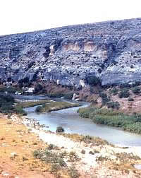
The Pecos River is shallow and mineral-rich.
Its source lies in northern New Mexico, some 685 miles
above its confluence with the Rio Grande. Photo from
ANRA-NPS Archives at TARL.
|
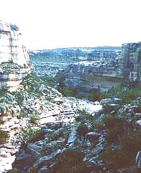
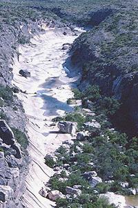
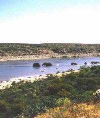
Mile Canyon, one of many short, narrow
side canyons that empty into the Rio Grande. The canyon
wall in the far background is across the Rio Grande
in Mexico. Photo from ANRA-NPS Archives at TARL.
|
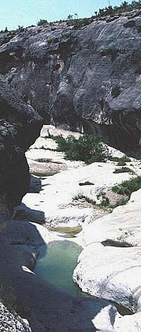
The twisting canyon tunnels form
a closed-in world framed by white-rock walls and the
blue sky high above. Sound, water, and critters travel
through the canyon tunnels, seeking each other and
the hidden green pools of water—tinajas. Photo
by Steve Black.
|
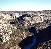
Seminole Canyon. In the background
the canyon floor has been scoured by flood, in the foreground
stacked up boulders trap soil and moisture and provide
shelter for trees and shrubs. Photo by Steve Black.
|
Greasewood flat. Creosote bush or
greasewood, is typical of the Chihuahuan Desert. Photo from ANRA-NPS Archives at TARL.
|
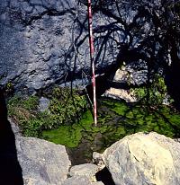
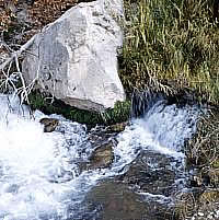
Small seep springs like this one
can be found in many of the canyons.
Photo from ANRA-NPS Archives at TARL.
|
|
Although the Lower Pecos Canyonlands
occupies only a small part of Texas, its natural world is far from uniform. It is, in
fact, a place marked by contrast: green and brown, canyon
and upland, one river and the next, yesterday and today. This
section introduces the natural world through
pictures and words.
The Lay of the Land
The Lower Pecos Canyonlands lies at the southwestern
edge of the Edwards Plateau—the Texas Hill Country as
most know it—which in turn lies at the southern edge
of the Great Plains. It also is within the northeastern edge
of the Chihuahuan Desert. The area is located along
the middle part of the Rio Grande drainage basin just below
the S-shaped "Big Bend" where the river turns southward
toward the Gulf of Mexico. It is there that the Rio Grande
is joined by the last two major streams that feed its middle
and lower stretches—the Pecos River, and the Devils River.
And it is the juncture of these three rivers that forms the
core of the Lower Pecos Canyonlands.
Within the region, the Rio Grande embankment
is dissected by precipitous canyons and arroyos that enter
the river on both sides. North of the Rio Grande, the land
is level to hilly and is cut by numerous canyons. South of
the Rio Grande lies an extensive plain broken by intermittent
streams that originate in the Serranias de los Burros, a mountain
range rising to almost 5,000 feet (1,524 meters). These mountains
parallel the Sierra del Carmen of Mexico and the southern
escarpment of the Edwards/Stockton Plateau. The southern part
of the Burros are dominated by the 4,700-foot-tall Cerro Oso
Blanco (White Bear Peak), which is located about 70 kilometers
(43 miles) southwest of Del Rio.
The deep canyons and porous limestone geological
formations of the region give rise to numerous permanent or
temporary streams and springs that stand in contrast to the
xeric (desert-like) nature of the plains and plateau country
that they dissect. The three permanent streams—the Rio
Grande, the Pecos River, and the Devils River—are the
life blood of the region, providing water and refuge to plants,
animals, and people. The Pecos River enters the Rio Grande
just 26 miles (42 kilometers) northwest of the confluence
of the Rio Grande and the Devils River. All three major streams
are joined by numerous small intermittent streams that form
narrow side canyons and break up the surrounding topography
into ridges, mesas, and fingers overlooking the deep green
winding worlds of the rivers.
The uplands and canyons
really are two worlds that make one. Upon the uplands the
horizon stretches forever, a jagged purple-blue line that
slowly fades to black at dusk. Up on top, the wind sculpts
squinting faces, sets ceniza and ocotillo branches to dancing,
and fuels the rusty silver flash of a well-oiled windmill.
There is no lasting natural reprieve from the relentless sun;
the trees are small and dark clouds all too infrequent. In
the best of times, the upland flats are grassy plains that
once lured herds of buffalo down from the north. In the worst
of times, there is nothing but thorn, rock, and dust.
And down below, the twisting canyon tunnels
form a closed-in world framed by white-rock walls and a blue
sky high above. Sound, water, and critters travel thorough
the canyon tunnels, seeking each other and the hidden green
pools of water. The tenacious roots of sheltered trees try
to hold the canyon floor together. But in time, each scene
changes as canyons become half-choked with washed-in soil
and the plant life that gladly follows, only to be scoured
clean by a once-in-three-lifetimes deluge. The rockshelters
provide only temporary refuge from the relentless cycles of
the canyon world: night cool and day heat, drought and flood,
bare rock and green plant. They, too, crumble with time.
Many large springs are located within and adjacent
to the Lower Pecos Canyonlands due to its location at the southwestern
edge of the Edwards Plateau. These springs occur mainly along
the Balcones fault zone where underground rivers (aquifers)
come in contact with impervious geological formations, forcing
the water to escape to the surface under artesian pressure.
Just east of the Lower Pecos Canyonlands, San Felipe Springs are
the fourth largest springs in Texas and still serve as the
sole source of water for the city of Del Rio. Goodenough Springs,
also one of the largest springs in Texas, is located beneath
the waters of Amistad Reservoir in a side canyon of the Rio
Grande. Although surface water was confined to narrow canyons,
numerous springs also existed on the plains to the south of
the Rio Grande. The abundance of permanent streams and springs
means that water was seldom a limiting factor to travel.
The Modern Climate
The southern and western edges of the Lower
Pecos region receive an annual average of as little as 10
inches of rainfall, while the northeastern edge averages almost
19 inches per year, figures which place the area within a
semi-arid climatic zone. Most precipitation occurs in two
peaks, one in spring (April-May) and one in early fall (September-October),
both fueled by thunderstorms at frontal boundaries fed by
moisture from the Gulf of Mexico and sometimes the Pacific.
The heaviest, drought-busting rains occur when tropical storms
stall over the area, sometimes dumping devastating, canyon-scouring
quantities of rain in a matter of hours or days. The driest
months of the year occur in winter from November to March,
and in summer from June to August. The frost-free period averages
300 days between February 13 and December 8. The average annual
temperature is 70ºF, ranging from a low of 51ºF
in January to a high of 86ºF in July.
Although these averages give a general impression
of climate, the truly interesting aspect of southwestern Texas
climate is its variability. The Lower Pecos Canyonlands region is positioned
at two great climatic crossroads of the North American continent—along
the sharp line between the humid east and the arid west, as
well as the more ambiguous divide between the markedly seasonal
regimes to the north and the winterless tropical climes to
the south. Consequently, the region encompassing southern
Texas and northeastern Mexico has a semiarid, subtropical
climate with dry winters and hot summers. More critically,
the climatic region containing the Lower Pecos has a greater
degree of year-to-year rainfall variation than any other semiarid
region in the world, except for northeastern Brazil. Rainfall
is highly unpredictable and drier-than-normal years are much
more common than extremely wet years.
In short, the Lower Pecos Canyonlands lies within a climatically
transitional region that can shift from a relatively well-watered
green and grassy place to a dusty brown desert in a matter
of years or even months. It is a marginal region for intensive
land use—plant and animal populations are quickly affected
by fluctuations in precipitation. Throughout its history,
humans have had to cope with climatic uncertainty, savoring
the good months and years and suffering the many bad ones.
Vegetation
Mirroring the terrain and climate, the Lower
Pecos lies within a major transition zone where three great
biotic provinces converge. To the southeast is the mesquite
and thorn brush savannah of the South Texas Plains. To the
north, the vegetation grades into the juniper-oak savannah
associated with the Edwards Plateau, while Chihuahuan Desert
Scrub covers the core area of the lower canyonlands of the
Devils River, the Pecos River, and the Rio Grande and farther
south.
Overall, the Lower Pecos area is a savannah with
a mix of grasses, brush, and trees. Depending on the local
conditions, the area may favor shrubs or grasslands. The southeastern
edge of the Lower Pecos Canyonlands is part of the mesquite-acacia
savannah of southern Texas. To the west, vegetation rapidly
grades into sotol-lechuguilla-creosote bush vegetation typical
of the Chihuahuan Desert. Despite the fact that the region
is technically a savannah, woody plants dominate the vegetation
in most upland areas within the boundaries of the reservoir
today. These include mesquite (Prosopis glandulosa),
several species of acacia (Acacia spp.), whitebrush
(Aloysia gratissima), Texas persimmon (Diospyros
texana), blue sage (Salvia ballotiflora), lotebush
(Ziziphus obtusifolia), various buckthorns (Condalia
spp.), and spiny hackberry (Celtis pallida). Creosote
(Larrea tridentata) and ceniza (Leucophyllum frutescens)
are prominent in many areas. Along the upper reaches of canyons,
succulents and rosette-stemmed evergreens are also common,
including prickly pear and tasajillo (Opuntia spp.),
several yuccas (Yucca spp.), and Agave lechuguilla.
Small trees are confined to narrow canyons or creek terraces.
Littleleaf walnut (Juglans microcarpa), several species
of oak (Quercus spp.), Mexican ash (Fraxinus greggii),
and Texas persimmon (Diospyros texana) are a few of
the more prominent tree resources located in the canyons.
Large stands of Huisache (Acacia farnesiana) and mesquite
(Prosopis glandulosa) occur on certain of the broad
terraces in the eastern part of the region.
Paleoenvironment
Despite the remarkable detail of the prehistoric
vegetation record contained in numerous, well-preserved rockshelter
deposits, only the general outline of the environmental history
of the Lower Pecos is known well. It appears that the Chihuahuan
Desert has expanded and contracted throughout the late Pleistocene
(prior to 9,000 B.C.) and Holocene (or Recent) periods, leaving
widespread relict populations of certain plants in favorable
microenvironments such as the protected and relatively well-watered
canyons. This is critical for two reasons. First, prehistoric
peoples often relied on these relict or stranded populations
of plants that are otherwise not commonly available in the
area. Second, the mix of local and relict plant communities
makes it difficult to reconstruct past environments because
all but the most drastic vegetation changes are masked in
the archeological deposits.
The general climatic trends can be seen in the
pollen record. As allergy sufferers know only too well, during
certain times of the year certain plants release large amounts
of pollen. Some of this pollen rain survives, especially in
permanently wet places like swamps and in very dry places
like the rockshelters of the Lower Pecos Canyonlands. By studying samples
from deposits of known ages, pollen experts have reconstructed
the paleoenvironment of the region at least in broad terms.
Decreasing frequencies of pine pollen indicate that the region
was slowly drying throughout the Holocene, with a brief wet
interval occurring around 2,500 years ago marked by an increase
in pine and grass pollen frequencies.
While pollen provides a very general view of
regional vegetation, most of what is known about Lower Pecos Canyonlands
vegetation has been gleaned from the analysis of plant remains
found in archeological deposits in the dry caves and rockshelters.
The best known shelter in the Lower Pecos area is
Hinds Cave which was excavated by archeologists from Texas
A&M in the 1970s. The Hinds Cave work showed that plants
common in the Lower Pecos Canyonlands today, including lechuguilla (Agave
lechuguilla), yuccas (Yucca torreyi and Y. rostrata),
sotol (Dasylirion texanum), acacias (Acacia greggii
and A. rigidula), prickly pear (Opuntia phaeacantha),
shin oak (Quercus pungens var. vaseyana), mesquite
(Prosopis glandulosa,) and juniper (Juniperus spp.),
were well established in the Lower Pecos Canyonlands by 7000 B.C.
|
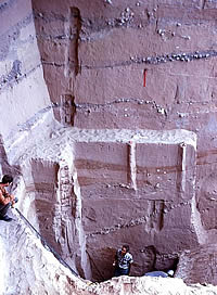
In its lower reaches, the Pecos River
carved a deep canyon entered by many side canyons. This
photo was taken during the 1966 excavations at Arenosa
Shelter, which is visible in the center of the picture.
Today this area is choked by massive silt deposits that
have built up since Amistad Reservoir was formed. Photo
from ANRA-NPS Archives at TARL.
Click images to enlarge
|
The lower Devils River prior to the
construction of Amistad Reservoir. Although much shorter
than the Pecos and the Rio Grande, the Devils River
is spring fed and its waters are clear and "sweet"
compared to the often muddy and salty waters of the
other two. Photo from ANRA-NPS Archives at TARL.
|
Numerous springs issuing out of the
Edwards Aquifer feed the Devils River. Photo from ANRA-NPS
Archives at TARL.
|
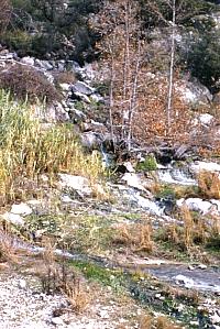
Spring-fed tributary of the Devils
River. Photo from ANRA-NPS Archives at TARL.
|
Innumerable canyons like this one
provide shelter for plants, animals, and humans. Photo from ANRA-NPS Archives at TARL.
|
|
Throughout Lower Pecos history, humans have had
to cope with climatic uncertainty, savoring the good
months and years and suffering the many bad ones.
|
Many of the deeply incised canyons
are lined by cliffs, their walls so steep that they
are all but invisible until you are almost standing
on the canyon edge. Viewed from the air, the canyons
form tree-like patterns with the rivers as trunks and
the smaller streams and side canyons forming limbs and
branches twisting and turning across the land. Photo
by Steve Black.
|
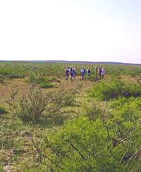
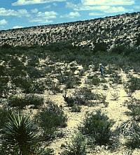
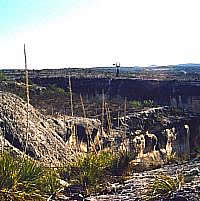
An archeological survey team gathers
on this upland area. Standing in the middle of one of
the flat upland areas between the canyons, it looks
as though vast unbroken plains stretch in every direction.
Yet less than a hundred yards away is a deep canyon.
Photo by Steve Black.
|
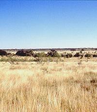
Prior to the introduction of sheep,
goats, and cattle, the upland areas of the Lower Pecos
Canyonlands had extensive grasslands like this restored area. During
wet climatic intervals, the grasslands flourished and
herds of buffalo migrated into the area. During one
such interval about 2800 years ago, hundreds of buffalo
were driven off the cliff above Bonfire Shelter. Photo
by Phil Dering.
|
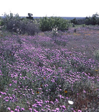
Flower-painted uplands after a wet
winter. Photo by Steve Black.
|
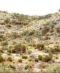
The towering flower stalks of the
sotol plant are a common sight in the Lower Pecos Canyonlands. Sotol
prefers thin rocky soils and steep terrain and often
grows in great abundance in such areas. Prehistoric
peoples harvested sotol hearts or "cabezas"
(heads) in quantity and baked them in earth ovens. Photo
by Phil Dering.
|
|
