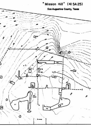
The story of the search for Mission Dolores is one of frustration, persistence, and, finally, success. The historically minded citizens of San Augustine had long been certain the mission had been located just were local tradition had it – atop “Mission Hill” a prominent high point to the east of, and overlooking, Ayish Bayou. Today this spot is not far south of downtown San Augustine. Yet, by the mid-20th century there were no visible traces of the mission.
In the early 1960s members of the San Augustine Historical Society became determined to “authenticate” the site of Mission Dolores. Naturally, they considered the mission to be a point of civic pride – San Augustine’s history stretched back some 250 years, making the town one of the earliest European settlements in East Texas. They wanted physical proof of exactly where the mission stood and dreamed of creating some sort of historical park, perhaps even reconstructing the mission. Over the next decade they repeatedly contacted archeologists at the University of Texas and the Texas Historical Commission asking for help. On at least five occasions researchers visited San Augustine and carefully searched Mission Hill for any positive signs of Spanish occupation.
First, in 1962, came three archaeologists from the University of Texas, Professor Dee Ann Story and two seasoned field archaeologists, Ed Jelks and Lathel Duffield, who found a few scattered Spanish Colonial artifacts, but nothing definitive and no evidence of structural remains, even foundations. The next year two archeologists from the Texas Historical Commission visited and had the same result: almost nothing. In 1971 architectural historian Jim Malone of the Texas Historical Commission tried yet again. Where was the mission?
Keep in mind that these were all experienced researchers who knew what they were looking for. The locations of numerous other Spanish Missions across Texas were positively known and marked by concentrations of period artifacts – Spanish, French, and other European pottery, metal artifacts, beads, animal bones, and so on. At most such sites tell-tale evidence can be found by looking carefully at exposed and disturbed areas, of which there were several on Mission Hill. But try as they might the researchers found no concentrations of period artifacts, no traces of architectural features and only a few scattered artifacts dating to the period. Scattered finds of small sherds (fragments) of tin-enameled faience and majolica pottery, a hand-wrought square nail, and a few sherds of incised earthenware pottery like that made by Indian groups in the region hinted that the mission was nearby, but where?
The next archeologist to tackle the case of the missing mission was Dr. Kathleen Gilmore, a Dallas-based archaeologist and historian who specialized in the Spanish Colonial era and had found several other “missing” sites. Over two field sessions in 1972-1973, Gilmore and her students from the University of Texas at Arlington, archaeologists and students from Southern Methodist University, and various volunteers sunk holes into Mission Hill looking for buried evidence. A ditching machine was used to excavate eight narrow trenches as deep as 1.5 meters (about 5 feet) in hopes of finding stratigraphic evidence of Spanish Colonial structural features. In the disturbed and promising areas they spotted in the trench walls, they opened up hand-excavated test pits. They found many different features including wall trenches, trash pits, a well, and possible postholes. But most of these had artifacts dating to the 19th and 20th centuries, not the 18th century. Nonetheless, they found a few dozen artifacts that did date to the right period – more tin-enameled pottery, aboriginal pottery, square nails, and several other items.
By now, Gilmore had become convinced that the precise location of Mission Dolores was not atop the summit of Mission Hill north of the highway. Most of the Spanish Colonial artifacts she found came from the sloping terrain along the ridge that was crested by the hill. In other words, farther to the south across highway 147 on private property. Most of this area had been badly disturbed during the 19th and 20th centuries, most notably by the construction of State Highway 147 in the 1930s. The highway (known in town as Broadway Street) was thought to have followed the Camino Real, the “King’s Highway’ used by the Spanish to travel to and from East Texas. Gilmore, however, suspected that in the vicinity of Mission Hill the modern highway deviated from the original route of the ancient “highway.” During her final season (1973) she looked for traces of the Camino Real but found nothing definitive, noting that much of the area had been disturbed in the modern era.
The "Note"
By now the search for "Mission Impossible," as Gilmore dubbed it in 1973, had become a quest. It was somewhere close, but precisely where? Happily, in the fall of 1975 Dr. James (Jim) Corbin arrived in nearby Nacogdoches as a new assistant professor at Stephen F. Austin University in Nacogdoches. He writes in the introduction of his 1990 report:
I first became aware of the existence of Mission Dolores de los Ais in a note pinned to the door of my brand new, and still vacant, office at Stephen F. Austin State University in the fall of 1975. The note in essence said that the San Augustine Historical Society desperately needed an archaeologist to help them locate the site of the mission.
Julia Wade, then president of the San Augustine County Historical Society, was the one who had contacted SFA and made the request. The society hoped an archaeologist could provide more information about the nature and configuration of the buildings of the mission to enable a reconstruction of the mission complex as part of a bicentennial project planned for the following year, 1976. Corbin decided to take on the quest. He had the advantage of being only 30 miles away and he could use the search as a training opportunity for his students.
Gilmore's Suspicions Confirmed
Most of the investigations previous to 1976 had focused on the north side of State Highway 147 where the crest of the hill was located and where tradition had it that the mission had been located. While is likely that there had been some outlying mission-related features in this area, as suggested by the sprinkling of 18th century artifacts that Gilmore and earlier researchers had found, her excavations had not encountered intact features. Mission Hill proper (the area north of Highway 147) had been impacted by a private residence, sawmill, and railroad housing project. At the end of her 1973 field season, Kathleen Gilmore obtained permission to excavate a backhoe trench in the area south of state highway 147 and she encountered an apparent pit (disturbed soil profile), but did not have time to carefully investigate the feature.
In the summer of 1976 Corbin followed up on Gilmore’s suspicions and carried out new excavations in this area, south of the highway. The apparent pit Gilmore had encountered proved to be the remains of a Spanish Colonial well. Corbin also found evidence of a long wall trench that proved to be the perimeter wall of the mission compound, as well as three interior structures and four trash pits, all found in association with Spanish Colonial period artifacts. A segment of the Camino Real was also identified in the excavations. The trash pits had large amounts of animal bone and American Indian pottery fragments. European artifacts were also recovered, but in smaller amounts, and included ceramics, nails, horse gear, gun parts, bottle glass, and miscellaneous metal fragments.
At last, Mission Dolores had been found. |
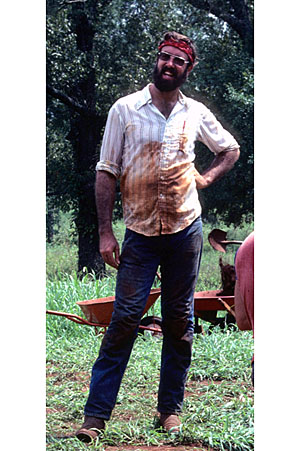
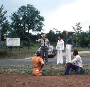
Jim Corbin takes a break from backfilling the excavations. SFA Archaeological Laboratory. |
|