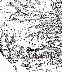
Kincaid Shelter lies in the Balcones
Fault Zone just below the southern edge of the Edwards
Plateau, an area deeply dissected by clear-flowing streams.
The fault line marks an abrupt transition from the elevated
limestone hills and canyonlands to the low, flat Gulf
Coastal Plain. Map adapted from Erwin Raisz.
|
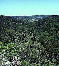
Steep hill slopes in the southern
Edwards Plateau are thickly forested with live oaks
and ashe juniper. Photo courtesy Texas Department of
Transportation.
|
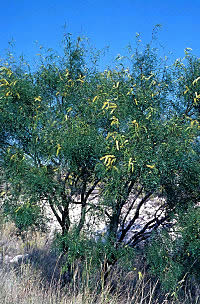
The thorny mesquite tree is prevalent
in south Texas and well up onto the Balcones Escarpment.
Its nutritious beans were an important food source for
aboriginal peoples. Photo by Benny J. Simpson, courtesy
of Texas A&M University at Dallas.
|
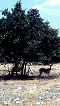
White-tailed deer browse oak trees
for acorns and graze on young forbes on the Edwards
Plateau. The animals, trees, and nuts were all important
resources for people during prehistoric times. Deer
bones were found in the upper (Archaic and Late Prehistoric)
levels at Kincaid Shelter. Photo courtesy Texas Department
of Transportation.
|
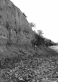
A crew member from the 1953 UT-Austin field school
inspects the stream bank cut in front of the shelter.
TARL archives.
|
|
Kincaid Shelter (41UV2) is a stratified archeological
site in Uvalde County, Texas, an area poised between the verdant,
rugged beauty of the Hill Country and the more desert-like
plains of South Texas. Carved into a low limestone bluff of
the Cretaceous-age Anacacho formation, the shelter extends
inward to form a semi-circular "room" roughly 32
feet deep by 35 feet wide (about 10 by 11 meters) in size.
The shelter ceiling is an irregular dome, a feature which
suggests that the shelter may have formed as a solution cavern
later dissected by the river cutting into the bluff.
The shelter is located in the Balcones Fault
zone near the northern edge of the Rio Grande Plain. There,
the low flat land of the coastal plain gives way to a belt
of low rolling hills and rocky terrain that marks the southern
margin of the Edwards Plateau. Changes in surface elevation
are abrupt, ranging from about 900 feet (275 m) above sea
level near the shelter to more than 1,900 feet (582 m) above
sea level on the plateau. The climate of the region is semi-arid,
and in the vicinity of the Kincaid Shelter (as well as farther
south) the climate is somewhat hotter and drier than on the
higher plateau.
The Kincaid Shelter lies within an ecotone,
or transitional zone between different plant communities—the
Tamaulipan biotic province of the coastal plain and the Balconian
biotic province of the Edwards Plateau. For prehistoric peoples,
this meant a rich mix of resources—nuts, fruits, seeds,
and various kinds of wildlife—was available nearby. By
striking off in different directions, different sets of resources
were encountered.
The Tamaulipan is dominated by thorny and arid-adapted
brush such as mesquite, acacia, cenizo, white brush, prickly
pear and tasajillo. Within the Balconian province, oak and
juniper savannas dominate the uplands and slopes and hardwood
forests line canyons and valleys. Bald cypress, sycamore,
black willow, pecan, black walnut, and other trees thrive
along more-permanent streams. Species characteristic of both
biotic provinces occur in the immediate vicinity of Kincaid
Shelter.
The Sabinal River today flows within 500 feet
of the shelter. Its headwaters lie about 40 miles to the north
on the Edwards Plateau. Within the plateau, the river is deeply
entrenched in Cretaceous limestones of the Glen Rose, Comanche
Peak, and Edwards formations. Springs issuing from the porous
Glen Rose maintain a nearly permanent flow of water for a
distance of 20 to 25 miles. During periods of normal flow,
the water disappears underground at the Balcones Fault zone
not far upstream from Kincaid Shelter. The water drains into
thick streambed gravels and through a series of fractures
in the Edwards Limestone. During major floods, the Sabinal
flows across the fault zone and onto the Gulf Coastal Plain
where it joins the Frio River.
At Kincaid Shelter, the Sabinal is dry most
of the time, but a semi-permanent pool is present about 2500
feet (762 meters) downstream. This pool has been known to
dry-up in historical times (e.g. summer of 1953), but standing
water persisted in another pool about one-half mile upstream
from the shelter. A pool also remained about three miles downstream
during the prolonged drought of the 1950s.
In the vicinity of the shelter, the Sabinal
River bed is floored with modern limestone gravel bars that
rise 6 to 8 feet above the river bed. An incipient flood plain
(alluvial terrace), whose surface averages about 14 feet above
the stream bed, also occurs as disconnected "bench"
segments along the present channel. These modern deposits,
still in the process of active development, are not directly
related to any of the cultural material in the Kincaid Shelter.
An older, well-developed alluvial terrace is
closely related to the cultural deposits in and near the shelter.
This terrace abuts the bluff that contains the Kincaid Shelter,
and some of the upper deposits within the shelter extend outward
and are incorporated into the terrace material. The terrace
surface extends as a broad brush-covered flat from the bluff
to the present river channel, and lies about 25 feet (7.6
m) above the river bed. According to local ranchers, floods
have spread across the terrace several times since 1900. These
major floods have not much modified the level of the terrace
surface, as there has been only a small amount of deposition
or erosion since the latest aboriginal occupation in the area.
The age of the oldest part of the 25-foot terrace
is not known. Archaic-period cultural materials and modern
faunal remains (animal bones) are present in the upper part
of the terrace in front of the shelter. Thus, the terrace
reached its final development in the Holocene (modern) geological
period. This terrace deposit is equivalent to the second terrace
that occurs in the upper Sabinal River valley of the Edwards
Plateau.
Viewed over the millennia, the land has constantly
changed and continues to do so. Looking back to the time of
the first peoples at Kincaid, the scene would have appeared
quite different from what we see today. During the relatively
cool and moist Late Pleistocene period, the Sabinal was a
more constantly flowing river able to support wildlife such
as alligators and aquatic turtles, as indicated by faunal
material from the lower deposits of the shelter. Megafauna—mammoth
and large bison—as well as camel, horse, and sloth roamed
the region.
The climate appears to have experienced a relatively
brief dry period sometimes called the Clovis Drought around
13,000 years ago. By 12,000 years ago the climate shifted
to a moderately moist period that lasted to perhaps 9,000
years ago, followed by a prolonged period of warm and dry
conditions that lasted for over 4,000 years punctuated by
a a brief moist interlude sometime between 5,000 and 6,000
years ago. By about 4,000 years ago, the climate shifted back
to somewhat wetter conditions similar to the modern climate.
As the climate fluctuated between dry and moist
periods over time, the vegetation and animal communities shifted
as well. Prehistoric hunters and gatherers, keenly attuned
to the land and its changing resources, would have adapted
or moved on.
|
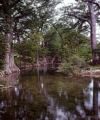
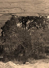
Water is plentiful from the Sabinal
River and other streams near Kincaid. Upstream of the
site, the Sabinal forms deep pools and is shaded by
massive bald cypress trees, as shown here. TARL archives.
Click images to enlarge
|
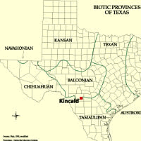
Map of Texas biotic provinces based
on the distribution of plant and animal communities.
As shown, Kincaid Shelter lies in an ecotone or transition
zone between the semi-arid, thorny brushlands of the
Tamaulipan province and the oak-juniper savannas of
the Balconian province. This mosaic of environments
with diverse resources likely made the area attractive
to prehistoric hunters and gatherers. Map courtesy Lyndon
B. Johnson School of Public Affairs. Click to enlarge.
|
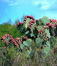
A prickly pear cactus, heavy with
bright fruits known as tuna, is a common sight in the
fall on the Edwards Plateau and on the Gulf Coastal
Plain. Photo courtesy Texas Parks and Wildlife Department.
|
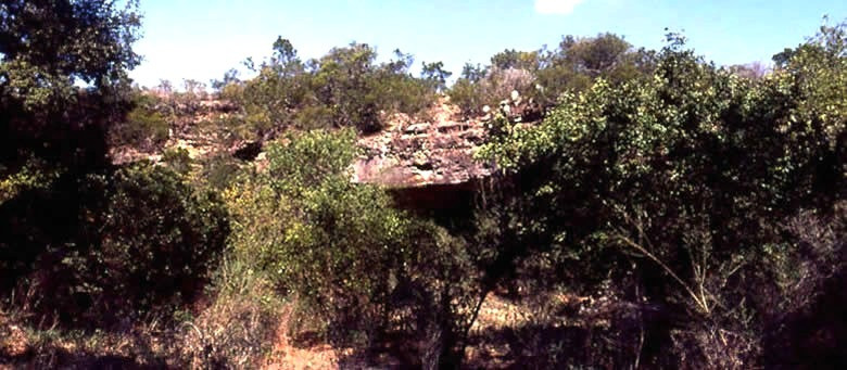
View looking outward from the shelter.
The limestone was dissolved by water percolating downward
over the eons, leaving a domed cavern that was eventually
exposed by erosion. Photo by Glen Evans, TARL archives.
Click to see full image.
|
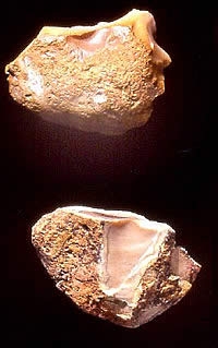
Chert, such as these Uvalde gravels,
was readily available in the Sabinal riverbed for making
stone tools. Although the Anacacho limestone at the
shelter locale contains no chert, the Sabinal crosses
harder, chert-bearing Edwards Limestone upstream of
the site. Photo by Tom Hester.
|
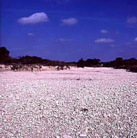
Yards of gravel line the Sabinal
River bed in front of the shelter, where the water flows
underground within limestone cracks much of the time.
The gravels were an important resource for prehistoric
peoples, providing flint cobbles (chert) to make into
tools and weapons and limestone or sandstone to use
for food grinding and to pave the shelter floor. Photo
by Tom Hester.
|
|