|
Solid evidence about the native peoples who occupied the Trans-Pecos Mountains and Basins from 1535 to the early 1800s is exceedingly sparse. Most of the data come from Spanish documents. Some additional information has come from the archeological remains of Indian camps dating to the early historic period, but most late sites are fragile and many have been covered by later buildings, destroyed by modern land use, stripped of artifacts by collectors, or have simply not been found and investigated. So the documentary evidence is our principal source of information on the native peoples of the region at the time they were encountered by Europeans.
Luckily, the Spanish were remarkable note-takers. During journeys taken by priests and the military, someone was assigned the task of keeping a journal that documented the events of each day. Sometimes the entry is terse, noting only the leagues traveled that day (a league is the Spanish measurement for distance, ca. 2.2 to 2.7 miles long), the direction of that travel (northeast, southwest, etc.), and often assigning a place name to the spot where camp was made. Oftentimes, however, the journalist included details about the Indians encountered that day. When the travelers encountered Indians, the Spanish always sought information from them, both because native resistance to the Spanish presence was fairly common and it was important to know where enemies might be, and because, as the newcomers, the Spanish wanted to learn more about the land and the people ahead on the trail. Consequently, using interpreters, they asked the Indians where they came from, where they were going, and anything they knew about other Indians in the vicinity or what the land was like further down the trail. A summary of that information was often put into the journal entry for that day.
During some trips, a cartographer was also present and a map was made of the journey, particularly if the trip was for military reconnaissance or was the first time the Spanish had ventured into that part of New Spain, as northern Mexico, Texas, and the southwest were known at that time. While there are far fewer maps than documents, these maps provide valuable information that has been used to study the native peoples of the Trans-Pecos at Spanish contact. Often maps show tipi or house symbols and the name of the native group living at that camp is written in a caption. Given the mapping equipment of the era and the overall unfamiliarity of the Spanish with west Texas, the maps have many errors and many omissions. Nonetheless, the maps give researchers group names and approximate geographic location of the groups at that moment in time.
Spanish documents are not confined to journals of travelers. Thousands of documents on land transfers, interrogations of settlers and natives, trial proceedings, periodic reports to the king, viceroy, or other officials in administrative capitols, and on other matters were written. Ethnohistorians (researchers who use documents and other archival materials to study the past) and to a lesser extent archeologists use these documents for the information they provide on the native peoples. For example, in 1748 Captain Joseph de Berroteran was asked to report on the condition of the northern frontier of Nueva Vizcaya (a northern province in New Spain that covered all of the modern Mexican state of Chihuahua and parts of the states of Coahuila and Sonora as well as the area of Presidio, Texas). A career soldier in charge of the Presidio (fort) of Conchos and a large landowner, Berroteran had first hand knowledge of the natives in the region. At the same time, he was frustrated by the lack of funds to pay for adequate forces to ensure the safety of towns, ranches, and friendly natives. The report is long and details nearly 50 years of events related to Spanish-Indian interaction. In one passage, he details information about a number of native groups from the Presidio, Texas area, called by the Spanish La Junta de los Rios (“the joining of the rivers”) because here the Conchos River enters the Rio Grande:
In the year 1726, during the month of March, the news arrived that the [illegible] Indians had advanced as far as the presidio of El Paso [Texas] with the Apaches and Cholomes who come from the Rio Puerco [another common name for the Pecos River] where it joins with the Rio [Grande] del Norte from its confluence with [the Conchos?]. They [the first group of Indians] came from Coyame [a town in northern Chihuahua today]—better known by this name than by that of [illegible]—which is 8 to 10 leagues away from the junction of the Rio del Norte and is numbered among [the pueblos of La Junta de los Rios]. Two Franciscan missionary fathers and two of their servants were at this mission. [The Indian allies] killed [the servants] and seized the reverend fathers, planning to kill them as well. They would have done so had not the principal leaders of La Junta [de los Rios] come to the rescue of the fathers. The Indians, seeing that their forces were too weak to counter the superior [force] of the enemies, stated that [the fathers] should be taken alive to La Junta, for they and their people also wanted to take part in the killings and scalp dances.
Using this strategy, the nortenos [the people of La Junta] managed to take the priests to their pueblo, San Francisco. Assembling their people together, they started a war against their former allies, killing some and capturing others.”
This passage and others in reports, journals, and other documents provide evidence about mobility, relationships, and negotiation among native peoples. The passage also discusses how relations among various named groups were negotiated. Used in combination with other accounts, ethnohistorians are able to tease information about how leaders operated to maintain (or not) harmony. Because native travel was rarely by horse in the early 18th century, the hostile Apache and Cholome Indians had walked from modern Del Rio to El Paso and then back to Presidio. This indicates an amazing ability to travel long distances on foot and at the same time it underscores their intimate knowledge of the landscape over a broad region.
By 1726 only one Spanish expedition had traveled from the area of Del Rio, Texas to eastern New Mexico. That was the expedition of Castana de Sosa in 1590, and it was a disaster. Berroteran himself was ordered to open a route from Monclova, Mexico up the Rio Grande to El Paso in 1729. He failed to do so because of the cliffs, the mountains, and the lack of water that would make such travel exceedingly difficult along this route even today, especially on horseback. No other serious explorations of the Trans-Pecos were attempted by Spain.
While the documents have provided wonderful new insights into the natives who occupied the Trans-Pecos, they are not without their problems. Access to the documents themselves is part of why our understanding of native peoples is limited. The documents are housed at archives in Mexico and Spain. Some major universities in Texas, Arizona, and New Mexico now have copies of a significant quantity of the documents. However, most are on microfilm and poorly indexed, although some universities are now undertaking efforts to make them available in digital format. Obviously all of them are in Spanish. Those who do not read Spanish cannot get much from the documents, and keep in mind that Spanish has changed considerably over the centuries in word meaning, grammar, and style. Other difficulties include the fact that the script they were written in is not modern, and penmanship quality is variable. Also abbreviations were commonly used in Spanish documents, and some words have multiple abbreviations—even in the same document. The would-be reader faces a steep learning curve. In addition, prior to being microfilmed, the documents often suffered from water staining and other ravages of time. Given these difficulties, some researchers, especially when working with time and funding constraints, have resorted to using only those documents that have been previously translated into English. While this is understandable, it limits our understanding of the native peoples of the Trans-Pecos.
We would be remiss if we did not also note yet another problem of the documentary data: bias. The documents are biased by the very Spaniards who wrote them. Most were not trained observers. Thus, their writings are incomplete recordings of what they saw or heard. As well, few Spaniards could speak the native languages, so they relied on interpreters who may or may not have always given them the true meaning of what was being said. Finally, each party in the exchange had his/her own agenda: the journalist, the interpreter, and the speaker.
The other data that gives us insights into what we know of the Native Americans of the Trans-Pecos are archeological. To date, however, archeological data has given only limited insights into the native peoples of the Trans-Pecos during the Colonial era. Most excavation has been limited to Spanish Colonial mission sites, such as Mission Socorro in Socorro, Texas near El Paso. Excavations at Spanish sites provide some data about native groups and their encounters with European norms, religion, and food products. However, excavations of native sites that date to this time frame have been few. In part, this relates to our inability to clearly date such sites, as radiocarbon results from the period after A.D. 1700 are difficult to interpret. And many historic period campsites were also prehistoric campsites and deposits of differing time periods are often mixed. In fact, most of the artifacts in historic Indian sites look the same as the artifacts from earlier centuries. So, unless a glass trade bead, a piece of Spanish metal, or some other trade item is recovered from the site, archeologists can not say if the site dates to 1650 or 1350. Another reason why so few sites of this time period have been identified and investigated is that few large scale archeological projects have been carried out in the Trans-Pecos.
Nonetheless, some sites dating to this time frame have been recorded and a few have been excavated. Among these are sites of the Cielo complex in the area from Presidio east through the Big Bend region of Texas and south into northern Mexico. Cielo complex sites are recognizable because most contain stacked stone enclosures that represent the lower walls of above-ground brush houses—wickiups. Cielo sites can contain several dozen of these enclosures, and they are always situated on well elevated landforms that provide panoramic views of desert basins and canyon drainage systems.
Excavations indicate that Cielo Complex sites represent seasonal encampments (villages, really) that were occupied repeatedly by extended families and small bands, beginning about 1350 and continuing until ca. 1650. The artifacts recovered from these sites include mostly stone artifacts distinctive of the Late Prehistoric period and sometimes a glass trade bead. The artifacts and food remains indicate a people who hunted, gathered vegetable food, and sometimes fished for their food, but who did not use pottery as no ceramics have been found at these sites. Because the sites were repeatedly occupied, it is not clear whether large groups came together at some of these sites at certain seasons or if new enclosures were constructed when the same extended family band returned to the site in successive years. Nonetheless, Cielo complex people were mobile and they favored highly defensible places to live.
Cielo sites are among the historic-era native sites present in the La Junta district, although they are always located on the periphery of the river valleys. Along the river proper, more substantial villages of flat-roofed jacales (mud-plastered pole-frame houses) that were partially below ground (built within pits) were seen by the first Spanish visitors—Cabeza de Vaca and his companions in 1535. The villagers grew domesticated crops of corn, beans, and squash, but also ate mescal (baked agave), buffalo, and various other wild plants and animals. See the La Junta de los Rios exhibit to learn more.
In addition to documentary and archeological data, we use ethnographic evidence to piece together information about the groups who occupied the Trans-Pecos when the Spanish first arrived. Ethnographies (purposeful eyewitness studies by trained observers, anthropologists) of modern and recent groups of hunters and gatherers and small-scale agriculturalists from elsewhere in the world suggest models that can be used to try to make sense of the archeological data in a site. Thus, worldwide cross-culture studies lead us to expect that sites of hunters and gatherers are occupied only for the period when the group residing there could acquire enough food to sustain themselves—perhaps a few days or a few weeks. Small scale agriculturalists, on the other hand, usually live in the same homes for a number of seasons. Only in times of stress—drought, floods, exhaustion of the land, etc.—would they relocate.
The ethnographic record is, however, not that simple, and often we find that good studies reveal how impoverished our understandings are. For example, the Chemehuevi who occupied the Mojave Desert in California were hunters and gatherers who lived in small family groups similar to other hunters and gatherers elsewhere in the world. Because their region was an arid desert, they often re-located when local food or water sources were exhausted. Their pattern of re-location seems similar to those seen in many other arid environments. Yet, through the eyes of Carolyn Laird, a linguist, who met and married a Chemehuevi in the early 1900s, we are able to see how much richer their lives were. Their mobile life-style was centered around a series of songs. The songs described a number of trails (e.g., Salt Trail, Bird Trail, etc.) and also described the birds, animals, water, and food to be found along the trail. Each family and individual was free to travel anywhere within the territory occupied by the Chemehuevi, but a man’s hunting territory was limited to the land that was traversed by the song that he had inherited from his father. Moreover, the songs led the families from one mountaintop to the next. These types of vivid and enlightening details cannot be re-captured from the archeological record. And sadly, no comparable ethnographic studies were ever done in the Trans-Pecos because no native groups living a native lifestyle still existed in the region when anthropology began in the late 1800s and early 1900s.
So, we know what we know about the native peoples of the Trans-Pecos Mountains and Basins region by cobbling together the bits and pieces of documents, archeological evidence, and other things not mentioned (like environmental observations) to try to understand aboriginal life as it was when the Spanish first traveled through this region. We know painfully well that the information we have to work with is imperfect. Each researcher has to decipher the clues, decide what to believe and what to reject, and otherwise read between the lines.
|
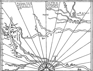
Map drawn ca. 1602 by the Spanish cartographer Enrico Martinez depicting the general area of Texas, New Mexico, and southern Oklahoma based on information obtained from Onate’s explorations of those lands. In the left and lower left the map shows New Mexico, the Rio Grande (called the "rio del norte" and "Rio Bravo"), the Pecos River ("Rio Salado"), the Conchos River in northern Mexico, and Onate's travel path from Santa Fe to large villages in the Great Plains. Note how the Pecos is incorrectly shown to parallel the Rio Grande and to join it far upriver from where it actually does. Traced from facsimile of the original. From Kenmotsu and Wade 2002, Figure 11. |
This 1650 French map drawn by the outstanding cartographer Nicolas Sanson d’Abbeville shows how little was known about the geography of western North America at the time. The R. de Norte (Rio Grande) is shown draining into the Gulf of California. The Trans-Pecos is terra incognito although the French did know the names of some of the Indian groups encountered by the Spanish including the Sumas, Passaguates, Tobosos, and Iumanes (Jumanos). Map Source: Contours of Discovery, 1982, Texas State Historical Association. Enlarge to see more details and larger area. |
Mapping the Trans-Pecos
Imagine mapping a land that had never been mapped before; think of what a daunting task that would be. Like most of us today, the natives would have carried mental maps in their heads visualizing how to go from one place to another across an intimately known landscape with many features and spots for which they had distinctive names. They had no need to draw such a map on parchment. When the Spanish came, they needed maps to be drawn to show leaders in far-away Mexico City and across-the-ocean Spain the locations of native groups, geologic deposits that might contain precious metals they could mine, cities, outposts, mountains, rivers, trails, and other places.
Spanish and Mexican cartographers were both famous and secretive. Spain knew that other European countries coveted the treasures that it had plundered from the New World, but they wanted those places kept secret. Hence, their maps were closely guarded by the Royal Cartographer, the chief map-maker who reported to the kings and queens of Spain. Occasionally, a map would be secretly copied and sold to another country or captured at sea, but most did not become widely known until decades or even centuries after they were made. European cartographers copied each other’s maps, adding details from various sources and using the spelling conventions of each language.
In the first centuries of exploration of the New World, Spanish maps show much greater detail and more accuracy of most of the New World than Dutch, French, or other maps. Yet, even the best Spanish maps were limited by what was known at the time and by the fact that mapping methods were relatively crude. As illustrated by the maps below, viewed over time, Spanish and other European maps show an emerging understanding of the lay of the land. Of the physical and cultural geography of Trans-Pecos proper, very little was actually known for several centuries because it remained seldom-visited and little-desired.
|
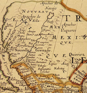
Greater Trans-Pecos portion of 1768 map by José Antonio de Alzate y Ramírez, a Mexican-born cleric and leading scientist educated at the best academies of New Spain. He created maps from records kept in the archives of Mexico, explorers' descriptions, and other maps of the day. This map is fairly accurately for the day and reflects the fact that most of the Trans-Pecos remained terra incognito. For orientation, follow the Rio Grande (“Rio del Norte”), which the Spanish knew well by the 18th century. As the map shows, the Spanish had a sustained presence in northern Mexico and New Mexico. The only settlements shown within the Trans-Pecos were those at ”Junta de los Rios del Norte y Conchos” and “el Pàso” where presidos (larger dark circles with flags), and named missions and villages (smaller circles and house symbols) were located. The most prominent Indian group depicted in the region is “los Sumas,” although other nations are shown in northern Mexico and Apaches are shown in many places to the north. Enlarge to see more details and larger area. |
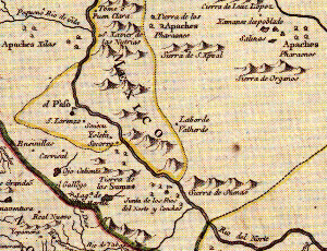
T rans-Pecos portion of 1776 map by British cartographer and publisher Thomas Jefferys reflects the inevitable geographic knowledge and publishing time lag of the day. Much of what the British knew about New Spain came from maps, charts, and sketches captured from Spanish warships as well as from published French maps. Although the geography and rivers are much less accurately depicted than the Alzate y Ramírez 1768 map, many more Indian nations are shown. Notice that the Apacheria (Apache-dominated territory) is shown spanning the Rio Grade (R. del Norte), the large size of the lettering showing the growing threat of the mounded raiders to the northern frontier of New Spain. Map source: David Rumsey Collection. Enlarge to see more details and larger area. |
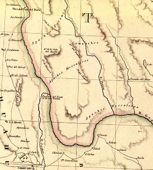
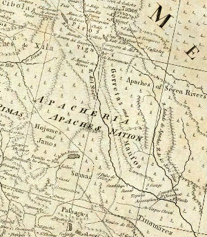
English map publisher John Arrowsmith’s 1841 map of the Republic of Texas is one of the first maps showing that the new republic’s territory extended west and southward to the Rio Grande in western Texas. The map also shows the areas then dominated by key Indian nations, namely the Apaches Mescaleros, Apaches Farones and the Comanches. Map Source: Contours of Discovery, 1982, Texas State Historical Association. Enlarge to see more details and larger area. |
|